Signal No. 2 up in parts of Mindanao with 'Odette' now a typhoon

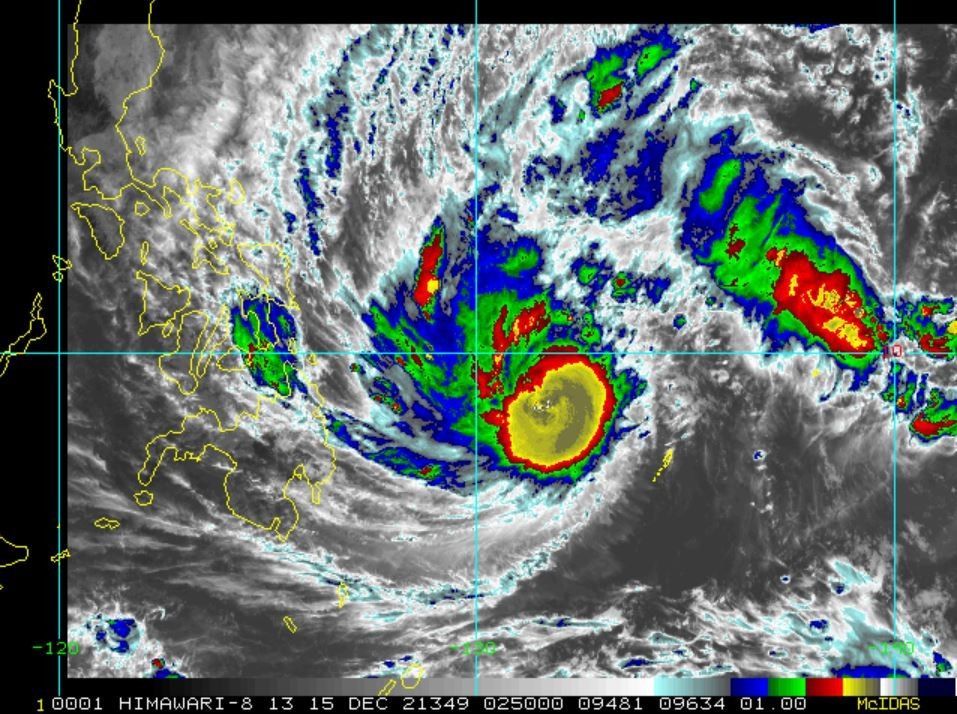
MANILA, Philippines — With Typhoon Odette (international name Rai) now classified as a typhoon, Tropical Cyclone Wind Signal No. 2 is up in a few areas in Mindanao, state weather bureau Pagasa said.
According to the latest weather bulletin issued by Pagasa at 11 a.m. on Wednesday, the center of Odette was last seen 590 km East of Hinatuan, Surigao del Sur moving westward at 20 kph.
Odette is also carrying maximum sustained winds of 120 kph near the center with strong winds or higher extending outwards up to 330 km from the center.
"Odette is forecast to move west-northwestward until this afternoon or evening, then westward thereafter," Pagasa said.
Tropical Cyclone Wind Signals
Signal No. 2:
- The eastern portion of Surigao del Norte (Claver, Siargao, and Bucas Grande Islands)
- Surigao del Sur
Signal No. 1:
- Sorsogon, Masbate including Ticao Island
- the southern portion of Romblon (Cajidiocan, San Fernando, Magdiwang, Alcantara, Looc, Santa Fe, San Jose)
- Eastern Samar
- Northern Samar
- Samar
- Leyte
- Biliran
- Southern Leyte
- Bohol
- Cebu
- Negros Oriental
- Negros Occidental
- Siquijor
- Iloilo
- Capiz
- Aklan
- Antique
- Guimaras
- Agusan del Sur, Agusan del Norte
- the rest of Surigao del Norte
- Dinagat Islands
- the northern portion of Bukidnon (Malitbog, Impasug-Ong, Sumilao, Manolo Fortich, Libona, Baungon)
- Misamis Oriental
- Camiguin
- the northern portion of Misamis Occidental (Plaridel, Baliangao, Sapang Dalaga)
- the northern portion of Zamboanga del Norte (Dapitan City, Sibutad, Rizal, La Libertad, Dipolog City)
Track, intensity outlook
The center is also forecast to make landfall in the vicinity of Caraga or Eastern Visayas tomorrow afternoon or evening. After, the center of Odette will continue moving generally westward and cross several provinces in Central and Western Visayas regions before emerging over the Sulu Sea on Friday morning or afternoon.
After passing near or over the Cuyo archipelago, it is forecast to cross the northern portion of Palawan on Friday evening before emerging over the West Philippine Sea.
"Odette intensified into a typhoon at 8 AM today. Further intensification is expected today through tomorrow as the typhoon crosses the Philippine Sea and may reach a peak intensity of 155 km/h prior to making landfall tomorrow afternoon," Pagasa also said.
"This tropical cyclone may see some slight weakening as it crosses the Visayas and Palawan, but it is forecast to remain within the typhoon category. Re-intensification is likely once Odette emerges over the West Philippine Sea."

Forecast positions
- 12-Hour Forecast 8:00 PM 15 December 2021: 475 km East of Surigao City, Surigao del Norte
- 24-Hour Forecast 8:00 AM 16 December 2021: 200 km East of Surigao City, Surigao del Norte
- 36-Hour Forecast 8:00 PM 16 December 2021: Over the coastal waters of Clarin, Bohol
- 48-Hour Forecast 8:00 AM 17 December 2021: Over the coastal waters of Cuyo, Palawan
- 60-Hour Forecast 8:00 PM 17 December 2021: Over the coastal waters of San Vicente, Palawan
- 72-Hour Forecast 8:00 AM 18 December 2021: 230 km East of Kalayaan Island, Palawan
- 96-Hour Forecast 8:00 AM 19 December 2021: 290 km Northwest of Pag-asa Island, Kalayaan Palawan (outside the PAR)
- Latest
- Trending


