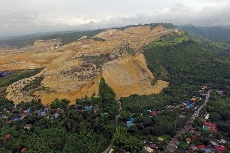
3 months after deadly landslide: Evacuees start to return home

CEBU, Philippines — After spending almost three months at the evacuation center, 975 families affected by the killer landslide in Barangay Tinaan, Naga City are now cleared to go home in time for Christmas.
Mayor Kristine Chiong said these are the families whose houses are located within the green and red areas on the Harmonized Map of Delineated Zones of the Mines and Geosciences Bureau (MGB).
MGB categorized the areas affected by the massive landslides into three -- green, red, and maroon.
Maroon is considered a Danger Zone, which means it is an active landslide and subsidence zone. Entry with caution will be restricted to activities involving hazard reduction and remediation measures. The area under maroon category is about 174 hectares. It is where ground zero is located.
No Permanent Habitation Zone is assigned the color red and covers 274 hectares. These are areas delineated as critical areas outside of ground zero because these were found to show signs of active landslides and subsidence. There should be no settlements in the zone.
The third is the 290-hectare Regulated Zone or green zone. It is temporarily closed to settlement and relocation site development until detailed landslide and subsidence hazard assessment is conducted.
“Outside of the critical area (families) may be allowed to go back to their homes na starting this afternoon until Dec 15 we are calling them per cluster,” said Chiong yesterday.
At present, the 975 families are staying in 10 evacuation centers located across the city of Naga. It is the LGU that provides the daily needs of the evacuees.
Before the evacuees are allowed to leave, they are required to attend an Information Education Communication (IEC) activity. During this time, they will be given warning cards and made to understand the risks should they return home as well as what they can do.
“You are allowed to go back but should always be advised nga magbantay gyud sila especially in times of ulan, in times of naay bagyo. Immediately if there’s a need to evacuate nga dili na sila storyhan sa gobyerno, mo-evacuate gyud sila,” Chiong said.
The city government is also working on giving them additional financial assistance before they can go back to their houses. The amount is yet to be finalized.
To further aid the residents, the local government unit has also tapped the Department of Science and Technology (DOST), Philippine Institute of Volcanology and Seismology (PHIVOLCS), and the Philippine Atmospheric, Geophysical and Astronomical Services Administration (PAG-ASA).
“We are engaging them to help the LGU come up with an integrated nga early warning system and also kung asa pang other areas sa Naga nga pwede nila nga mabutangan,” the mayor explained.
Unfortunately, 444 families whose houses are located within the Danger Zone have to wait for their permanent relocation. Chiong, however, said that these families are no longer staying at the evacuation centers. They are either renting or staying somewhere else with their relatives. The city government had already extended financial aid to them after the landslide.
Cebu Governor Hilario Davide III already signed the Deed of Donation for a portion of the Balili Property which will serve as relocation site. A total of 2.1 hectares of the controversial property will be utilized as the project site.
Chiong, however, said that the property is not enough to accommodate all the 444 families that needed immediate relocation.
“Actually it is not enough. It can only accommodate around 260 units,” she said.
She added that the city government is taking the initiative to look for other alternative areas. But Davide promised that the provincial government will continue to help Naga City.
“Sige lang mangita ta. As I’ve announced earlier, the provincial government will continue to assist the city of Naga. Dako pa man na’g area ang Balili,” he said.
At least 78 people were buried alive, 18 were injured and six remained missing after a massive landslide hit Sitio Sindulan, Barangay Tinaan, in Naga City on September 20. The landslide site covers 80.12 hectares.
The tragedy was blamed by the residents on the quarry operations of Apo Land Quarry Corporation and Apo Cement Corporation. In fact, a multi-billion peso class suit was filed by at least 39 residents against the quarry company and several government officials, including the local government units. (FREEMAN)
- Latest


