Signal No. 3 up over Babuyan Islands as 'Julian' gains strength
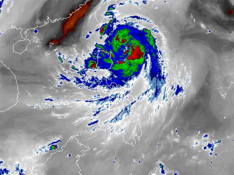
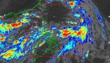
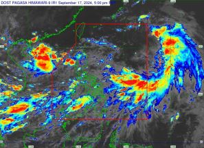
MANILA, Philippines — State weather bureau PAGASA has hoisted Signal Number 3 over the Babuyan Islands as Severe Tropical Storm Julian (international name: Krathon) further intensified while moving over the Philippine Sea.
As of 10 a.m. on Sunday, September 29, Julian was located 290 kilometers east-northeast of Aparri, Cagayan or 300 km east of Calayan, Cagayan.
Moving slowly west-northwest, the storm was carrying peak winds of 110 kilometers per hour near its center, with gusts of up to 135 kph and a central pressure of 985 hPa.
Wind signals
The following areas are under tropical cyclone wind signals (TCWS).
Signal No. 3
- northeastern portion of Babuyan Islands (Babuyan Is.)
Winds between 89 kph to 117 kph may be expected in at least 18 hours.
Residents of areas under Signal No. 3 could experience moderate to significant impacts from strong winds.
Signal No. 2
- Batanes
- northeastern portion of Mainland Cagayan (Santa Ana)
- rest of Babuyan Islands (Camiguin Is., Calayan Is., Dalupiri Is., Fuga Is.)
Winds between 62 kph and 88 kph may be expected in at least 24 hours.
Residents of areas under Signal No. 2 could experience minor to moderate impacts from strong winds.
Signal No. 1
- rest of Cagayan
- Isabela
- Apayao
- Abra
- Kalinga
- Mountain Province
- Ifugao
- Ilocos Norte
- Ilocos Sur
- northern portion of Benguet (Bakun, Mankayan, Buguias)
- northern portion of Aurora (Dilasag, Casiguran)
Winds between 39 and 61 kph may be expected in at least 36 hours or intermittent rains may be expected within 36 hours.
Residents of areas under Signal No. 1 could experience minimal to minor impacts from strong winds.
Heavy rainfall, severe winds
PAGASA warned of heavy rainfall, particularly for coastal and upland areas due to Severe Tropical Storm Julian.
The highest wind signal that may be raised is TCWS No. 4.
Strong to gale-force winds are expected in the following regions:
- Sunday, September 29: Aurora, CALABARZON, Romblon and Bicol Region
- Monday, September 30: Pangasinan, Zambales, Bataan, Aurora, Quezon, Romblon and Bicol Region
Hazards affecting coastal waters
PAGASA warned mariners of hazardous sea conditions and risky travel for small vessels, including motorbancas in the following areas:
- Batanes: Waves up to 9 meters (very rough)
- Babuyan Islands: Waves up to 7 meters (very rough)
- northern Cagayan and Ilocos Norte: Waves up to 4.5 meters (rough)
- Cagayan and Isabela: Waves up to 3.5 meters (rough)
- northern Aurora: Waves up to 3 meters (rough)
- remaining Ilocos Norte: Waves up to 2.5 meters (moderate)
Track and intensity outlook
Julian is projected to make landfall or come very close to Batanes and Babuyan Islands on Monday.
The storm is moving west-northwest and will shift to the north and northeast by Tuesday afternoon over the waters east of Taiwan.
PAGASA said that Julian will intensify into a typhoon by Sunday night, with a possibility of becoming a super typhoon.


- Latest
- Trending