The geological hazards of the Bataan Nuclear Power Plant
(First of a series)
Introduction
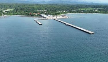
The Bataan Nuclear Power Plant (BNPP) that President Ferdinand Marcos had built on Napot Point at the seacoast in the Bataan town of Morong has an unacceptably high risk of serious damage from earthquakes, volcanism, or both, should it be activated in accordance with a bill currently being considered by the House of Representatives.
Marcos decided to build the BNPP in 1973, to address the first serious energy crisis that happened that same year. This rushed timing clearly indicates that the natural hazards of the site could not have been assessed properly. Such a study would have taken at least several years.
Marcos must not have known that more than the entire northern half of the Bataan peninsula consists of one large volcano, Mt. Natib, which even extends its base below sea level. In the 1970s, “volcaniclastic sedimentology” — the science of how volcanic explosion debris is produced, transported and deposited — had not yet even been formalized. Only in 1991 was the major international monograph Sedimentation in Volcanic Settings published. (It included one of the earliest formal uses of the term lahar, in an article on Mt. Mayon that I co-authored.)
When Pinatubo erupted in 1991, it left at its summit a huge “caldera,” a hole two kilometers in diameter. Much of the two to three cubic kilometers blown out to make the caldera formed “pyroclastic flows” — mixtures of very hot gases and rock debris that flowed down the sides of the volcano at speeds of 100 kilometers per hour or more, with temperatures of about 500°C.
Mt. Natib, a sister to Pinatubo, has two calderas, one as big as Pinatubo’s, the other more than twice as big, with a diameter of five kilometers. So Natib has erupted at least twice. And if caldera size is a valid measure, one of those eruptions must have been much larger than Pinatubo made in 1991.
Early concerns
In the 1970s, the volcanic nature of Natib was virtually ignored, but technicians were quite concerned about how earthquakes might affect the plant. Recognition of the dangers that earthquakes posed to the BNPP was recognized very early, but apparently was ignored. A year after construction began, nuclear technologists Elmer Hernandez and Gabriel Santos submitted an alarming eight-page “Report on the evaluation of the geological and seismological studies made on the Philippine Nuclear Power Plant — I Site” in which they said that the probability of an earthquake occurring there “is unacceptably very high,” and that 49 significant earthquakes had occurred in the area over 74 years, one within one to two kilometers of the proposed site itself. They also noted the presence of a possible fault in satellite photographs, which they confirmed on the ground with a magnetometer survey.
But construction continued anyway.
Nevertheless, the Philippine Atomic Energy Commission was concerned enough to send Prof. Ernesto Sonido, the geophysicist of the UP-Diliman Department of Geology and Geography, to investigate the site further in early 1979. On Jan. 25, Dr. Sonido reported that he and a Mr. John Palmer, the groundwater geological consultant of the contractor firm Ebasco, agreed on site that a fault zone existed in the vicinity of Napot Point. Faulting of otherwise impermeable rocks had made many fractures from which water was seeping. Palmer said that he had drilled more than 30 holes at the plant site. The boreholes encountered a particular rock at different depths, suggesting … “that the area had been tectonically active.”
When the plant was designed and built, the International Atomic Energy Agency (IAEA) of the United Nations had not yet made rules governing what must be done to build a plant on volcanic terrain. IAEA announced those criteria only in 1997, three years after volcanologists began to develop them, in the document “Volcanic Hazard in Nuclear Power Plant Siting — An IAEA Guidance — Provisional Safety Standards Series No. 1.” Had those standards existed in the 1970s, the BNPP would never have been built. And if applied today, the site would be unacceptable to the IAEA.
(To be continued)
* * *
Kelvin Rodolfo is concurrently professor emeritus with the Department of Earth and Environmental Sciences, University of Illinois in Chicago, and an adjunct professor with the National Institute of Geological Sciences, University of the Philippines-Diliman. He is currently a DOST Balik Scientist. Discussion and corrections are welcome at [email protected].
- Latest


