Cyclone ‘Leon’ intensifies into a super typhoon

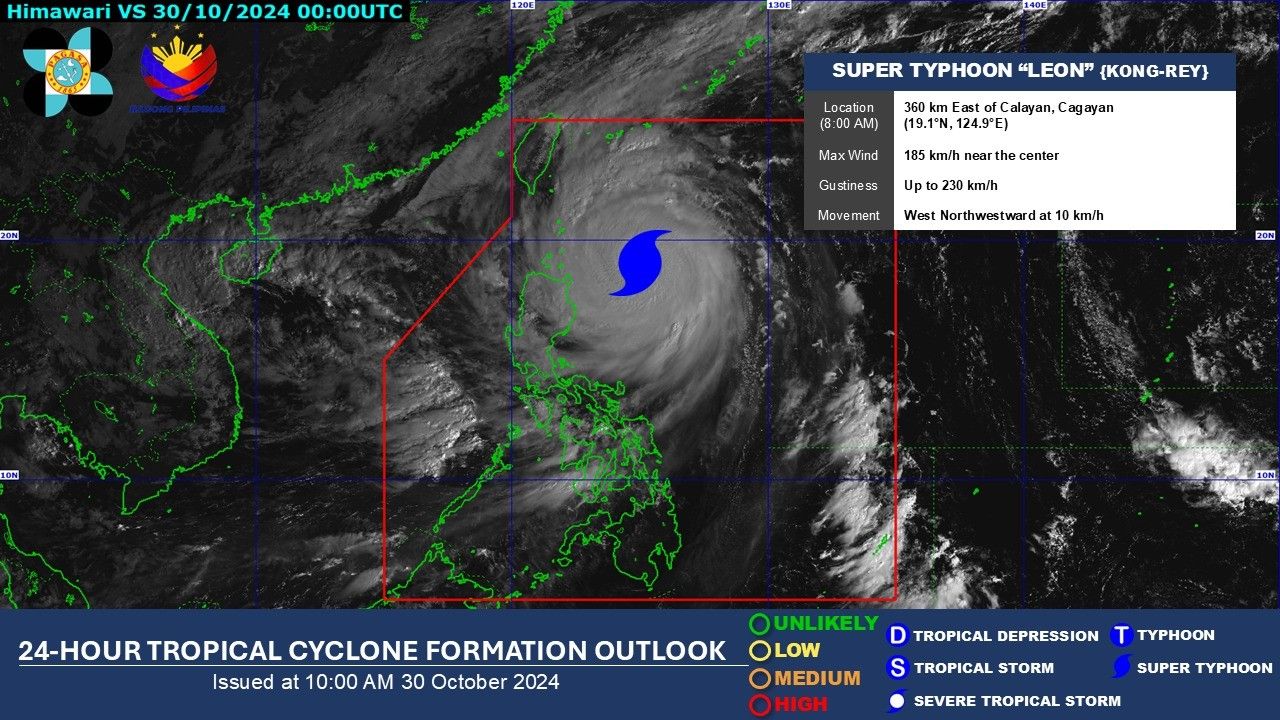
MANILA, Philippines (Updated 1:30 p.m.) — Tropical cyclone "Leon" has intensified into a super typhoon midday on Wednesday, October 30 as it passes through the northeast corner of the Philippine area of responsibility.
As of 10 a.m., PAGASA reported that Leon has maximum sustained winds of 185 kilometers per hour (kph) with gustiness of up to 230 kph.
Leon is currently 360 east of Calayan, Cagayan, moving west northwestward at 10 kilometers per hour.
In an earlier forecast, PAGASA said that Leon will exit PAR on November 1.
In its 11 am cyclone bulletin, PAGASA has hoisted the following Tropical Cyclone Wind Signal (TCWS) numbers in several areas:
TCWS No. 3
- Batanes
- eastern portion of Babuyan Islands (Babuyan, Camiguin, Calayan)
- northeastern portion of mainland Cagayan (Santa Ana)
TCWS No. 2
- rest of Babuyan Islands
- rest of mainland Cagayan
- northern and eastern portions of Isabela (Santo Tomas, Santa Maria, Quezon, San Mariano, Naguilian, Dinapigue, Delfin Albano, San Pablo, Ilagan City, Benito Soliven, Tumauini, Cabagan, Palanan, Quirino, Divilacan, Gamu, Mallig, Maconacon, Burgos, City of Cauayan, San Guillermo, Angadanan, Cabatuan, Luna, Reina Mercedes, Roxas, Aurora, San Manuel)
- Apayao
- Kalinga
- northern and eastern portions of Abra (Tineg, Lacub, Malibcong, Lagayan, San Juan, Lagangilang, Licuan-Baay, Daguioman)
- eastern portion of Mountain Province (Paracelis)
- Ilocos Norte
TCWS No. 1
- rest of Isabela
- Quirino
- Nueva Vizcaya
- rest of Mountain Province
- Ifugao
- Benguet
- rest of Abra
- Ilocos Sur
- La Union
- Pangasinan
- Nueva Ecija
- Aurora
- northeastern portion of Tarlac (Camiling, San Clemente, Paniqui, Moncada, Anao, San Manuel, Pura, Ramos, Victoria, Gerona, Santa Ignacia, City of Tarlac, La Paz)
- northern portion of Bulacan (Doña Remedios Trinidad, San Miguel)
- northern portion of Quezon (Infanta, General Nakar) including Polillo Islands
- Camarines Norte
- northern portion of Camarines Sur (Siruma, Tinambac, Lagonoy, Garchitorena, Caramoan)
- northern and eastern portions of Catanduanes (Pandan, Gigmoto, Bagamanoc, Panganiban, Viga, Baras, Caramoran)
A gale warning has also been issued over the seaboard of Northern Luzon and the eastern seaboards of Central and Southern Luzon.
PAGASA said that the hoisting of TCWS No. 5 has not been ruled out should Leon move to the left of its forecast track.
Leon will approach Batanes later this evening until tomorrow morning. A a landfall in Batanes is still possible.
- Latest
- Trending


