'Marce' now a typhoon

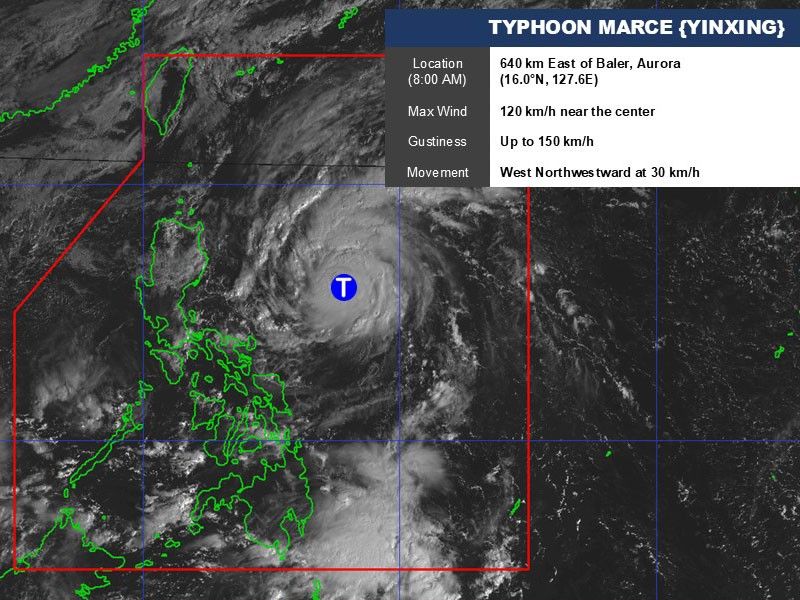
MANILA, Philippines (Updated 11:40 a.m.) — Tropical cyclone Marce (international name: Yinxing) further intensified into a typhoon as it approaches Northern Luzon on Tuesday, November 5.
As of 10 a.m., state weather bureau PAGASA said Marce was spotted 640 kilometers east of Baler, Aurora, as of 10 a.m. on Tuesday
Carrying peak winds 120 kilometers per hour near the center and gustiness of up to 150 kph, Marce is moving west northwestward at 30 kph.
Wind signal
The following areas are under Tropical Cyclone Wind Signal No. 1:
- Batanes
- Cagayan including Babuyan Islands
- Isabela
- Ilocos Norte
- Apayao
- Abra
- Kalinga
- Mountain Province
- Ifugao
- northern portion of Nueva Vizcaya (Diadi, Bagabag, Ambaguio, Villaverde, Bayombong, Solano, Quezon, Kasibu)
- northern portion of Quirino (Diffun, Saguday, Cabarroguis, Aglipay, Maddela)
- northern portion of Aurora (Dilasag, Casiguran, Dinalungan)
Strong winds ranging from 39 to 61 kph may be expected in at least 36 hours or intermittent rains may be expected within 36 hours.
Severe winds
PAGASA said the highest wind signal that may be hoisted is Signal No. 4.
Strong to gale-force gusts are expected over the following areas due to the northeasterly wind flow:
- Tuesday, November 5: Ilocos Sur, Aurora, Quezon and Camarines Norte
- Wednesday, November 6: Ilocos Region, Quezon, Camarines Norte, Camarines Sur and Catanduanes
Sea conditions
A gale warning remains in effect for the northern and eastern seaboards of Northern Luzon.
PAGASA advised mariners of hazardous sea conditions and risky travel for small vessels, including motorbancas in the following areas:
- Up to 5.5 meters: Isabela seaboard
- Up to 5 meters: Northern seaboards of Ilocos Norte and mainland Cagayan
- Up to 4.5 meters: Western seaboard of Ilocos Norte
- Up to 4 meters: Seaboards of northern Aurora and Ilocos Sur
- Up to 3.5 meters: Remaining seaboard of Ilocos Region; the northern and eastern seaboards of Polillo Islands; the seaboard of Camarines Norte; the northern seaboard of Catanduanes and Camarines Sur
- Up to 3 meters: Western seaboard of Zambales; eastern seaboard of Catanduanes.
- Up to 2.5 meters: Eastern seaboards of Albay and Sorsogon; northern and eastern seaboards of Northern Samar
- Up to 2 meters: Eastern seaboards of Camarines Sur, Eastern Samar, Dinagat Islands, Surigao del Sur, Davao Oriental, and Davao del Sur; western seaboards of Bataan, Lubang Islands, Calamian Islands, Kalayaan Islands and northern mainland Palawan
Track, intensity track
Typhoon Marce is moving towards Northern Luzon and could make landfall in the Babuyan Islands or northern Cagayan as early as Thursday night or Friday morning.
It is expected to slow down by Wednesday morning and shift westward over the Philippine Sea, just east of Northern Luzon.
Depending on the strength of a high pressure area north of Marce, the typhoon’s path could still change, potentially impacting the Cagayan-Isabela region.
The state weather bureau said Marce is likely to reach peak intensity before making landfall, bringing strong winds, heavy rains and rough seas to Northern Luzon.
Marce is expected to exit the Philippine area of responsibility late Friday or early Saturday.
- Latest
- Trending


