Storm Ferdie enters PAR; 2 more LPAs monitored
MANILA, Philippines — Tropical Storm Ferdie has entered the Philippine area of responsibility (PAR) even as two more weather disturbances that may develop into low-pressure areas (LPAs) are being monitored, according to the Philippine Atmospheric, Geophysical and Astronomical Services Administration (PAGASA).
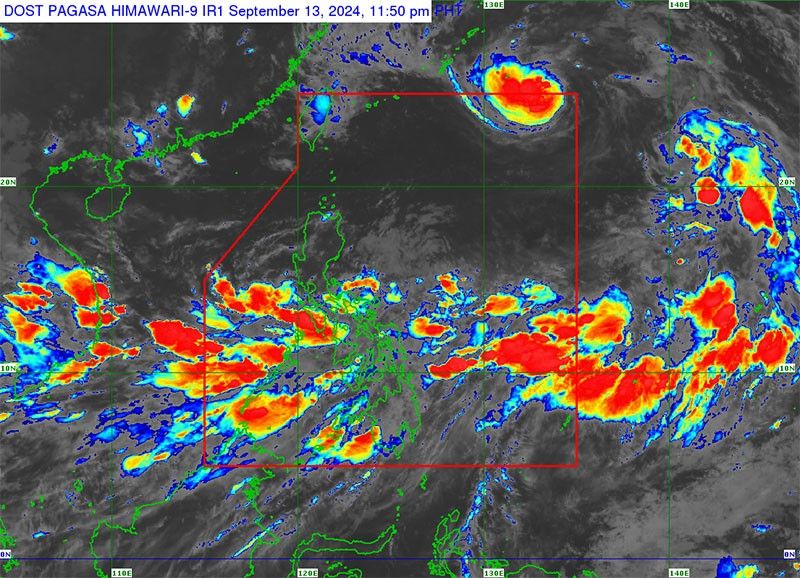
“At 6 p.m. (yesterday), Tropical Storm Bebinca entered the PAR and was assigned the domestic name of Tropical Storm Ferdie,” the weather bureau said.
At a press conference, PAGASA administrator Nathaniel Servando said Tropical Storm Ferdie has weakened into a tropical storm from a severe tropical storm.
Servando said Ferdie is expected to exit PAR today.
He added that despite the expected immediate exit of Tropical Storm Ferdie, it will enhance the southwest monsoon particularly in Mimaropa (Region 4-B), Southern Luzon, Western Visayas (Region 6),
including Negros Island, Mindanao, particularly the western part of Mindanao.
For her part, PAGASA senior weather specialist Glaiza Escullar said that Tropical Storm Ferdie was located 1,435 kilometers east northeast of extreme Northern Luzon with maximum sustained winds of 85 km per hour and gustiness up to 105 km/h as it is moving northwestward at 35 km/h.
“It will intensify into a severe tropical storm once it leaves PAR. It can also reach typhoon category once it reaches East China Sea,” Escullar said.
She added that the southwest monsoon being enhanced by the tropical storm has already caused strong rains in many parts of the country, particularly Southern Luzon, the Visayas and Mindanao.
“For the next three days, these areas will experience significant rainfall that may cause landslides and flooding,” Escullar said.
She said that as early as yesterday, heavy to intense rains or 100 to 200 millimeters (mm) of rains were experienced in Mimaropa, Western Visayas, Sorsogon, Masbate and Negros Occidental.
She added that moderate to heavy rains or 50 to 100 mm were experienced in Zambales, Bataan, Calabarzon, the rest of Bicol region, Metro Manila, rest of the Visayas, Misamis Occidental, Zamboanga del Norte, Lanao del Norte, Lanao del Sur, Maguindanao, Sultan Kudarat and Sarangani.
According to Escullar, today and tomorrow, Mimaropa, Aklan, Antique and northern Palawan are expected to experience heavy to intense rains brought by the enhanced southwest monsoon.
Meanwhile, she said that moderate to heavy rains will be experienced today in the Bicol region (region 5), Negros Island region and the rest of Western Visayas.
Escullar said moderate to heavy rains are also expected in the southern portion of Quezon, the rest of Mimaropa, Camarines Sur, Catanduanes, Albay, Sorsogon, Masbate, Negros Occidental, and the rest of Western Visayas by tomorrow.
Escullar said that once the weather disturbance east of the country develops into an LPA, the rains being experienced in the big portion of Southern Luzon, the Visayas and Mindanao will persist for six days.
She said that as of Sept. 12, the amount of rain experienced in Coron, Palawan reached as much as 243.8 mm; San Jose, Occidental Mindoro, 172.9 mm; Juban, Sorsogon, 159.6 mm; Baler, Aurora, 107.5 mm and Daet, Camarines Norte, 107.3 mm.
Meanwhile, officials have started to release water from Magat Dam in Isabela amid the threat of the tropical cyclone in the country, according to PAGASA.
Based on the 8 a.m. bulletin of PAGASA, at least one gate of Magat Dam is opened at one meter after it reached 188.06 meters or less than two meters before it reaches its normal high water level of 190 meters. – Rudy Santos


- Latest
- Trending