‘Romina’ continues to move toward southern Kalayaan Islands
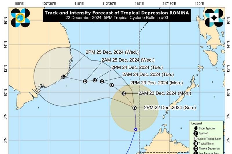
MANILA, Philippines — Tropical Depression Romina continues its trajectory toward the southern portion of the Kalayaan Islands, state weather bureau PAGASA said on Sunday, December 22.
As of 5 p.m., the center of Romina was located over the coastal waters of Rurok Island, Kalayaan, Palawan, outside the Philippine area of responsibility, moving northward at 35 kilometers per hour (kph).
It packs maximum sustained winds of 55 kph near the center and gusts up to 70 kph.
Rainfall
The weather bureau has advised the public to refer to Weather Advisory No. 27 for updates on heavy rainfall caused by Romina and the shear line.
Areas under Tropical Cyclone Wind Signal No. 1 may experience minimal to minor impacts from strong winds, with gusts potentially enhanced in coastal and upland areas.
The highest Wind Signal expected during Romina’s passage is Wind Signal No. 2, although this remains subject to change based on the cyclone's development.
Sea travel risks
A Gale Warning has been issued for the northern and western seaboards of Northern Luzon and the western seaboard of Southern Luzon.
Seas in affected areas may reach dangerous levels, with wave heights of up to 4.5 meters expected in the seaboards of Batanes, Babuyan Islands, Ilocos Norte and Kalayaan Islands.
Mariners are strongly advised to avoid sea travel, as conditions are hazardous for all types of vessels.
Rough seas, with waves reaching up to 4.0 meters, are forecast along the northern and eastern seaboards of Polillo Islands, Catanduanes, Camarines Norte, the northern seaboard of Camarines Sur and the eastern seaboard of mainland Cagayan.
Similarly, waves of up to 3.5 meters are expected in the seaboards of Isabela, Aurora, and northern mainland Quezon, as well as the eastern coasts of Albay, Sorsogon and Northern Samar.
In moderately rough seas, wave heights ranging from 2.0 to 2.5 meters are anticipated along the coasts of mainland Palawan, Calamian Islands, Cuyo Islands and the eastern seaboards of Davao Oriental and Surigao del Sur.
Mariners of small vessels and motorbancas are advised to exercise extreme caution and avoid venturing out under these conditions.
Track and intensity outlook
Romina is currently moving northward but is forecast to shift to a northwestward or west-northwestward direction within the next 24 hours. On this path, it is likely to pass near the southern Kalayaan Islands.
The tropical depression may briefly intensify into a tropical storm within 12 hours before weakening again into a depression.
- Latest
- Trending


