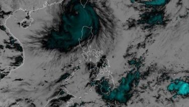
Storm 'Tino' may enter PAR early Monday - PAGASA
MANILA, Philippines - Tropical storm Wipha may enter the Philippine Area of Responsibility by Monday morning, the state weather bureau said Saturday afternoon.
The Philippine Atmospheric, Geophysical and Astronomical Services Administration (PAGASA) said that as of 4 p.m., the storm was estimated at 1,510 east of Northern Luzon.
"It is expected to enter the PAR by Monday morning," the weather bureau said.
PAGASA said the storm will be named "Tino" once it enters the PAR. It would be the 20th cyclone to enter the PAR this year.
The 20th cyclone immediately follows Typhoon "Santi," which has left five people dead in Central Luzon.
The typhoon hit land on Friday night, crossed Central Luzon and then exited through Zambales.
As of this posting, the typhoon was already over the West Philippine Sea and it was forecast to exit the PAR by Sunday afternoon.
- Latest
- Trending


