'Julian' now a typhoon
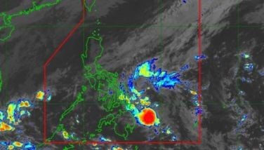
MANILA, Philippines — Tropical cyclone Julian (international name: Krathon) further intensified into a typhoon as Signal No. 3 remained hoisted over Babuyan Islands.
In its 2 p.m. weather bulletin, state weather bureau PAGASA reported that Julian was located 275 kilometers east of Calayan, Cagayan.
It is moving north-northwest at 15 kilometers per hour, carrying peak winds of 120 kilometers per hour and gusts up to 135 kph.
Wind signals
PAGASA raised tropical cyclone wind signals over the following areas:
Signal No. 3
- northeastern portion of Babuyan Islands (Babuyan Is.)
Winds between 89 kph and 117 kph are expected within at least 18 hours, with residents possibly experiencing moderate to significant impacts from strong winds.
Signal No. 2
- Batanes
- mainland Cagayan
- rest of Babuyan Islands (Camiguin Is., Calayan Is., Dalupiri Is., Fuga Is.)
- Apayao
- northern and central portions of Ilocos Norte (Pagudpud, Adams, Dumalneg, Bangui, Burgos, Pasuquin, Vintar, Carasi, Nueva Era, Solsona, Piddig, Dingras, Sarrat, San Nicolas, Laoag City, Bacarra)
Residents of areas under Signal No. 2 could experience minor to moderate impacts from strong winds, with winds between 62 kph and 88 kph expected within at least 24 hours.
Signal No. 1
- rest of Ilocos Norte
- Ilocos Sur
- northern portion of La Union (Santol, Sudipen, Bangar, Luna, Balaoan, San Gabriel, Bacnotan)
- Abra
- Kalinga
- Ifugao
- Mountain Province
- northern and central portions of Benguet (Bakun, Mankayan, Buguias, Kabayan, Atok, Kibungan, Bokod, Kapangan)
- Isabela
- Nueva Vizcaya
- Quirino
- northern and central portions of Aurora (Dilasag, Casiguran, Dinalungan, Dipaculao)
Winds between 39 and 61 kph may be expected in at least 36 hours or intermittent rains may be expected within 36 hours. Minimal to minor impacts from strong winds are anticipated.
Heavy rainfall, severe winds
Heavy rains are expected in affected areas, with risks of flooding and landslides in low-lying and mountainous regions.
PAGASA said that the highest wind alert that may be issued is Signal No. 4.
The following areas are likely to experience strong to gale-force gusts due to Typhoon Julian:
- Sunday, September 29: Aurora, CALABARZON, Romblon and Bicol Region
- Monday, September 30: Pangasinan, Zambales, Bataan, Aurora, Quezon, Romblon and Bicol Region
Hazards affecting coastal waters
PAGASA issued a gale warning for the northern and eastern coasts of northern Luzon due to Typhoon Julian.
Sea travel is dangerous for small boats, including motorbancas, in the following areas:
- Batanes: Waves up to 9 meters (very rough)
- Babuyan Islands: Waves up to 7 meters (very rough)
- mainland Cagayan and northern Ilocos Norte: Waves up to 4.5 meters (rough)
- remaining Cagayan and Isabela: Waves up to 3.5 meters (rough)
- northern Aurora: Waves up to 3 meters
- remaining Ilocos Norte: Waves up to 2.5 meters (moderate)
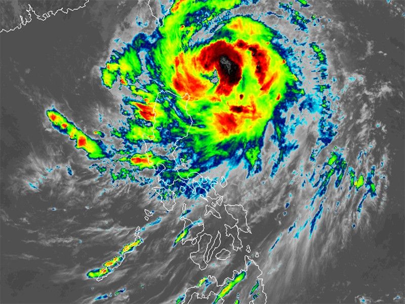
Track and intensity outlook
Typhoon Julian is forecasted to move west northwestward towards the Batanes-Babuyan Islands from Sunday through Tuesday morning, October 1.
The storm will then accelerate north to northeastward over the waters east of Taiwan on Tuesday afternoon.
A landfall or close approach over Batanes and/or the Babuyan Islands is expected by Monday.
PAGASA warned that Julian will likely intensify over the next 24 to 36 hours, with a possibility of reaching the super typhoon status.


- Latest
- Trending