‘Enteng’ maintains strength, Signal no. 2 up over parts of Luzon
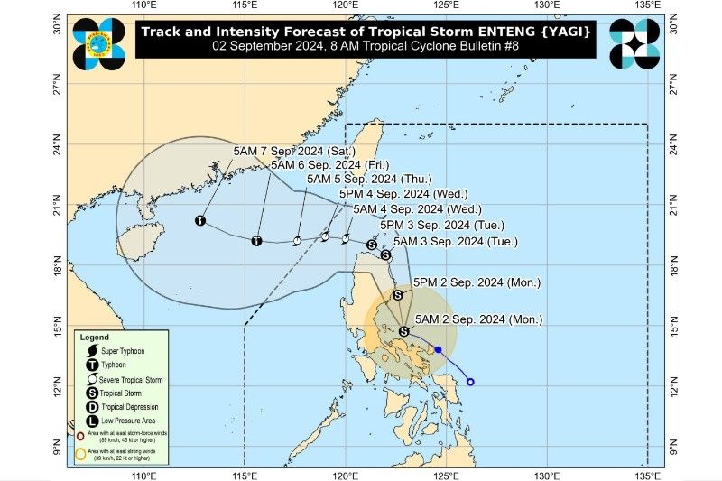
MANILA, Philippines — State weather bureau PAGASA has raised Tropical Cyclone Wind Signal No. 2 in several areas of Luzon as Tropical Storm Enteng (international name: Yagi) maintains its strength.
In its 8 a.m. Tropical Cyclone bulletin, "Enteng" was spotted 100 kilometers North Northwest of Daet, Camarines Norte or 115 km East Northeast of Infanta, Quezon (15.0°North, 122.7°East) moving west northwestward at 10 km per hour (kph). It packs peak winds of 75 kph and gusts of up to 90 kph.
Here are the Tropical Cyclone Wind Signals raised as of 8 a.m.:
Signal No. 2
- The northeastern portion of Camarines Norte (Vinzons, San Lorenzo Ruiz, Talisay, Daet, Labo, Paracale, Jose Panganiban, San Vicente, Basud, Mercedes, Santa Elena, Capalonga)
- Northeastern portion of Camarines Sur (Garchitorena, Caramoan, Presentacion, San Jose, Lagonoy, Tinambac, Siruma, Goa)
- Cagayan (Pe, Gonzaga, Santa Teresita, Buguey, Lal-Lo, Gattaran, Baggao, Santa Ana, Lasam, Santo Nino, Alcala, Amulung, Solana, Iguig, Tuguegarao City, Enrile, Aparri, Ballesteros, Camalaniugan, Allacapan, Piat, Tuao, Rizal, Abulug, Pamplona) including Babuyan Islands
- Eastern portion of Isabela (Santa Maria, Santo Tomas, Cabagan, Delfin Albano, Quirino, Gamu, Burgos, Luna, Reina Mercedes, City of Cauayan, Alicia, Echague, Jones, San Agustin, Angadanan, San Guillermo, San Pablo, Maconacon, Tumauini, Ilagan City, Palanan, Divilacan, San Mariano, Naguilian, Benito Soliven, Dinapigue, Cabatuan, Aurora, San Manuel, Mallig, Quezon, Roxas)
- Northern portion of Aurora (Casiguran, Dilasag, Dinalungan)
- Polillo Islands
- Eastern portion of Quirino (Maddela)
- Northern portion of Apayao (Luna, Santa Marcela, Flora, Pudtol, Calanasan)
- Eastern portion of Kalinga (Rizal)
Winds in these areas are expected to range from 62 to 88 kph, posing a minor to moderate threat to life and property.
Signal No. 1
- Batanes
- Ilocos Norte
- Ilocos Sur
- Eastern portion of Pangasinan (Rosales, Asingan, Binalonan, Sison, San Manuel, Santa Maria, Balungao, San Quintin, Tayug, Umingan, Natividad, San Nicolas)
- Abra
- Rest of Apayao
- Rest of Kalinga
- Mountain Province
- Ifugao
- Benguet
- Rrest of Isabela
- Rest of Quirino
- Nueva Vizcaya
- Rest of Aurora
- Nueva Ecija
- Eastern portion of Pampanga (Candaba)
- Eastern portion of Bulacan (Doña Remedios Trinidad, Norzagaray, City of San Jose del Monte, Obando, City of Meycauayan, Bocaue, Balagtas, Bustos, Baliuag, Pandi, Santa Maria, Marilao, Angat, San Rafael, San Ildefonso, San Miguel)
- Metro Manila
- Rizal
- Laguna
- Eastern portion of Batangas (San Juan)
- Rest of Quezon
- Marinduque
- Rest of Camarines Sur
- Albay
- Sorsogon
- Catanduanes
- Northern portion of Masbate (City of Masbate, Aroroy, Baleno) incuding Ticao and Burias Islands
Winds in these areas are forecast to be between 39 and 61 kph, with minimal to minor impacts expected.
Rainfall Outlook
Heavy rainfall is anticipated in various parts of Luzon, particularly in Camarines Norte, Camarines Sur, Albay, and Quezon, where more than 200 millimeters of rain is expected today, September 2.
Metro Manila, Bulacan, Aurora, and other parts of CALABARZON, Sorsogon and Catanduanes, are forecast to receive 100-200 mm of rain.
Meanwhile, Isabela, Quirino, Nueva Ecija, Marinduque, Romblon and Masbate are forecast to receive 50-100 mm of rain.
Track forecast
Enteng is expected to move further west northwestward and may exit the Philippine area of responsibility on Wednesday evening or Thursday morning, according to weather specialist Grace Castañeda.
There might also be a westward shift in the storm’s track due to the ridge of high pressure in the north of Enteng which may cause increased rainfall in mainland Luzon.


- Latest
- Trending