Signal no. 5 hoisted over Aurora, other areas ahead of ‘Pepito’s’ landfall

MANILA, Philippines — Tropical Cyclone Wind Signal (TCWS) No. 5 has been raised over parts of Aurora, Quirino and Nueva Vizcaya as Super Typhoon “Pepito” (international name: Man-Yi) is expected to landfall in the afternoon of Sunday, November 17.
State weather bureau PAGASA in its 2 p.m. tropical cyclone bulletin described Pepito as “dangerous and life-threatening” as it maintained its super typhoon category ahead of its landfall.
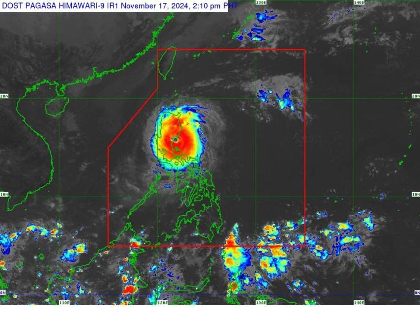
Pepito's center of the eye was located near the coastal waters of Baler, Aurora as of 1 p.m. It packs maximum sustained winds of 185 kilometers per hour (kph) near its center, with gustiness up to 230 kph and a central pressure of 935 hPa.
It is currently moving northwestward at 20 kph. The extent of its winds reaches up to 300 km from the center.
Tropical Cyclone Wind Signals
Signal No. 5
PAGASA placed the central portion of Aurora (Dipaculao, Baler, Dinalungan, Maria Aurora, Casiguran, San Luis), the southern portion of Quirino (Nagtipunan) and the southern portion of Nueva Vizcaya (Alfonso Castañeda) under tropical cyclone wind signal no. 5.
These areas are under extreme threat to life and property, according to Pagasa, with destructive winds surpassing 185 kph anticipated within the next 12 hours.
Signal No. 4
- The rest of Aurora
- The rest of Nueva Vizcaya
- The rest of Quirino
- The southern portion of Ifugao
- Kiangan
- Lamut
- Tinoc
- Asipulo
- Lagawe
- Benguet
- The southern portion of Ilocos Sur
- Alilem
- Sugpon
- Suyo
- Santa Cruz
- Tagudin
- La Union
- The eastern portion of Pangasinan
- Sison
- Tayug
- Binalonan
- San Manuel
- Asingan
- San Quintin
- Santa Maria
- Natividad
- San Nicolas
- Balungao
- Pozorrubio
- Laoac
- San Jacinto
- San Fabian
- Manaoag
- City of Urdaneta
- Rosales
- Umingan
- Mangaldan
- Mapandan
- Villasis
- Santo Tomas
- The northern portion of Nueva Ecija
- Gabaldon
- Laur
- Bongabon
- Pantabangan
- Rizal
- General Mamerto Natividad
- Lupao
- San Jose City
- Llanera
- Carranglan
- Science City of Muñoz
- Talugtug
- Cuyapo
- The northern and eastern portion of Polillo Islands
- Panukulan
- Burdeos
- Patnanungan
- Jomalig
These areas face a significant to severe threat to life and property, with typhoon-force winds ranging from 118 to 184 kph expected within 12 hours.
Signal No. 3
- The southern portion of Isabela
- San Agustin
- Jones
- Echague
- San Guillermo
- Angadanan
- Alicia
- San Mateo
- Ramon
- San Isidro
- City of Santiago
- Cordon
- Dinapigue
- Roxas
- San Manuel
- Aurora
- Cabatuan
- City of Cauayan
- Luna
- The rest of Ifugao
- Mountain Province
- The southern portion of Abra
- Tubo
- Luba
- Pilar
- Villaviciosa
- San Isidro
- Pidigan
- Langiden
- San Quintin
- Bangued
- Manabo
- The rest of Ilocos Sur
- The rest of Pangasinan
- The northern and eastern portions of Tarlac
- Paniqui
- La Paz
- Moncada
- City of Tarlac
- Gerona
- Pura
- San Clemente
- Santa Ignacia
- Victoria
- Camiling
- Concepcion
- Ramos
- San Manuel
- Anao)
- The rest of Nueva Ecija
- The northern portion of Bulacan (Doña Remedios Trinidad, San Miguel)
- The northern portion of Quezon (Infanta, General Nakar) including the rest of Polillo Islands
These areas face a moderate to significant threat to life and property, with storm-force winds ranging from 89 to 117 kph expected within 18 hours.
Signal No. 2
- The rest of Isabela
- The southwestern portion of mainland Cagayan
- Enrile
- Tuao
- Solana
- Tuguegarao City
- Piat
- Rizal
- Kalinga
- The southern portion of Apayao (Conner, Kabugao)
- The rest of Abra
- Ilocos Norte
- Zambales
- Bataan
- Pampanga
- The rest of Bulacan
- Metro Manila
- Rizal
- Cavite
- Laguna
- The central and eastern portions of Quezon
- Pitogo
- Buenavista
- Lucena City
- Calauag
- Pagbilao
- Tiaong, Lopez
- Guinayangan
- Unisan
- General Luna
- Plaridel
- Quezon
- San Antonio
- Alabat
- Candelaria
- Lucban
- Sampaloc
- Padre Burgos
- Sariaya
- City of Tayabas
- Macalelon
- Mauban
- Dolores
- Perez
- Agdangan
- Gumaca
- Atimonan
- Real
- Tagkawayan
- Camarines Norte
- The northwestern portion of Camarines Sur (Del Gallego, Ragay, Lupi, Sipocot)
These areas face a minor to moderate threat to life and property, with gale-force winds ranging from 62 to 88 kph expected within 24 hours.
Signal No. 1
- The rest of mainland Cagayan
- The rest of Apayao
- Batangas
- The northern portion of Occidental Mindoro (Abra de Ilog, Paluan) including Lubang Islands
- The northern portion of Oriental Mindoro (Puerto Galera, San Teodoro, Naujan, Baco, Victoria, Socorro, Pinamalayan, Gloria, Pola, City of Calapan)
- The northwestern portion of Romblon (Banton, Corcuera, Concepcion)
- Marinduque
- The rest of Quezon
- The rest of Camarines Sur
- Catanduanes
- Albay
- The northern portion of Sorsogon
- Donsol
- Pilar
- Castilla
- City of Sorsogon
- Prieto Diaz)
- Burias Island
Coastal and marine hazards
A high risk of life-threatening storm surge is forecast within the next 48 hours, with peak surge heights exceeding three meters in low-lying or exposed coastal areas of the Ilocos Region (western coast), Isabela, Central Luzon, Metro Manila, Calabarzon, Marinduque and the Bicol Region.
A gale warning is still in effect for the eastern and western seaboard of Luzon.
PAGASA also warned that sea travel is considered risky for all types of vessels.
Mariners and seafarers are urged to remain in port or seek shelter in a safe harbor as soon as possible until winds and waves subside.
Forecast track
Pepito is expected to move generally west northwestward or northwestward, making landfall near Aurora between 2 p.m. and 5 p.m. on Sunday, November 17.
It will then move across the northern part of Central Luzon and the southern portion of Northern Luzon, passing through the upland regions of the Sierra Madre, Caraballo and Cordillera Central on Sunday afternoon and evening.
The typhoon is forecast to exit Luzon’s landmass tonight or early tomorrow, November 18.
As it moves over the West Philippine Sea, Pepito is expected to continue traveling west northwestward on Monday, November 18, potentially exiting the Philippine area of responsibility (PAR) by tomorrow morning or noon.
Once outside the PAR, it will shift to a more westward or west southwestward direction on Tuesday, November 19, due to the influence of an incoming northeasterly wind surge.
- Latest
- Trending


