Space agency maps quake-triggered landslides in Mindanao
MANILA, Philippines — Satellite images have detected about 138 hectares of possible landslide areas in Sarangani and Davao Occidental after the magnitude 7.8 earthquake that struck Mindanao on June 8, the Philippine Space Agency said.
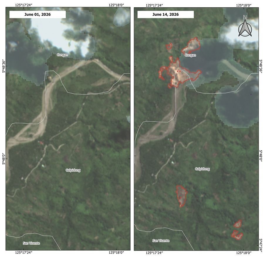
PhilSA said it produced maps showing earthquake-induced landslides in five barangays in Glan, Sarangani and six barangays in Jose Abad Santos, Davao Occidental.
The possible landslide areas covered barangays Calabanit, Ilaya, San Vicente, Congan and Calpidong in Glan, and barangays Butuan, Patulang, Sugal, Nuing, San Isidro and Batulan in Jose Abad Santos.
The combined area possibly affected by landslides was estimated at 137.87 hectares, or about 1.38 square kilometers. PhilSA said this is more than half the land area of Bonifacio Global City.


How satellites detected landslides
PhilSA said the landslide areas were identified by comparing vegetation loss between pre-disaster images taken on June 1 and post-disaster images taken on June 14 from the Sentinel-2A and Sentinel-2B satellites of the European Space Agency.
Areas that appeared green and covered in vegetation before the quake but appeared brown after the disaster indicated bare soil and possible landslide areas, the agency said.
Vegetation loss was measured through a significant decrease in Normalized Difference Vegetation Indices between the satellite images.
PhilSA cautioned that the mapped areas are still subject to ground validation.
The agency said its satellite analysis provides wide-area coverage that can help the National Disaster Risk Reduction and Management Council monitor the situation and prioritize areas for response.
Quake aftermath. The maps were produced as Mindanao continues to deal with the aftermath of one of the strongest earthquakes to hit the country in recent years.
Recent government figures placed the death toll at 78, with 1,339 injured and 30 others missing. More than 1.6 million people have been affected, while about 88,000 remain displaced, according to separate disaster monitoring reports.
More than 84,000 houses have also been damaged across affected areas.


- Latest
- Trending