


Mini Murillo maps further debunk China’s claim
MANILA, Philippines — It’s exactly 10 years since the Philippines’ landmark unanimous 2016 win against China over the West Philippine Sea at the Permanent Court of Arbitration in The Hague.
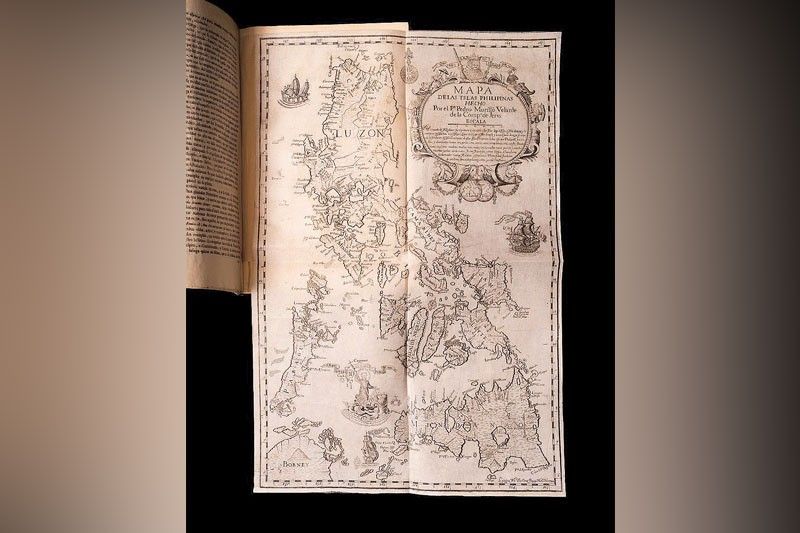
That triumph was built on the Murillo Velarde Map of 1734, considered “the mother of all Philippine maps,” which decisively proved that the Panacot island (Scarborough Shoal) and the Los Bajos de Paragua (Spratlys) – much less the waters around them – were never under the sway of China.
Two more Murillo Velarde maps – one dated 1744 and the other 1788, of approximately one-fourth the size of the first map – have surfaced for the Leon Gallery Asian Cultural Council Auction in Makati this Feb. 14. All three maps were engraved by the Filipino Nicolas de la Cruz Bagay, who described himself as a “Manilan.”
More importantly, they are part of important 18th-century books on the history of the Philippines and the rest of Asia, making them that much more significant testimony to the country’s ownership of its territorial waters.
The first is attached to Padre Pedro Murillo Velarde’s own narrative, “Historia de la Provincia de Philipinas de la Compania de Jesus” (or “History of the Philippine Province of the Society of Jesus”). This monumental work, published in Manila in 1749, documents the Jesuit missions and their role in the colonial history of the country from its earliest period, 1616 to 1716.
The second map was included in an even broader work by Juan de la Concepcion, encompassing 14 volumes and the history not just of the Philippines but all of Southeast Asia, including Japan and, more tellingly, South China.
The now invalidated Chinese claim on the West Philippine Sea is based on a “‘Location Map of the South Sea Islands’ released within China in February 1948 with 11 dashes forming a broken U-shaped line covering almost the entire South China Sea.” The assertion was made 214 years after the Murillo Velarde map was made and was debunked by a team led by then Supreme Court associate justice Antonio Carpio at The Hague tribunal.
The tribunal concluded that China’s claims to historic rights over resources within the sea areas have no legal basis under international law, specifically the United Nations Convention on the Law of the Sea or UNCLOS.
Fatal defects
Meanwhile, in Zamboanga City, retired justice Carpio continued to expose the “fatal defects” of China’s claim over islands in the West Philippine Sea with historical maps that copied British names translated into Chinese.
Carpio, speaking last week at the launching of The Murillo Bulletin Basilan themed “We’ve Always Been on the Map,” underscored the historical basis of the Philippines’ territorial claims to debunk and expose the weaknesses of China’s assertions over the disputed areas.
His presentation focused on the 1875 Carte Général de Archipelago Filipino and other key historical documents.
Carpio cited historical evidence showing the Philippines’ longstanding claim over the Spratly Islands and Scarborough (Panatag) Shoal, specifically maps that predate China’s assertions by centuries.
Carpio noted that while the map is not currently in any Philippine public museum or library, efforts are underway to secure an original print.
He traced China’s territorial claims through official Chinese publications issued by China under the Kuomintang.
According to Carpio, China’s territorial claim traced to its official 1943 handbook stated that China’s southernmost territory extended only to Triton Island in the Paracels (Basu).
At that time, China did not claim Scarborough Shoal or the Spratly Islands. — Roel Pareño


- Latest
- Trending


