2 areas under Signal No. 5 as 'Pepito' menaces Bicol with 'life-threatening' impacts

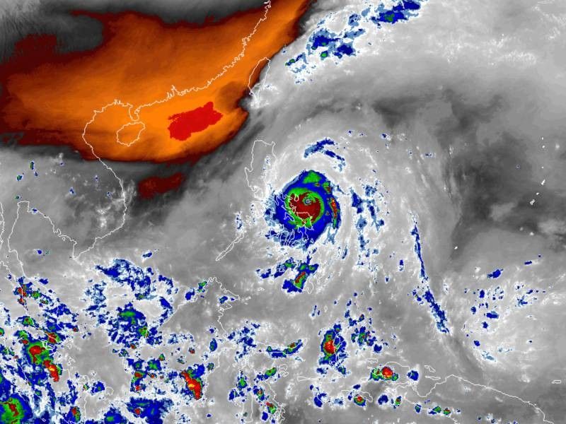
MANILA, Philippines — Super Typhoon Pepito (international name: Man-Yi) has strengthened as it approaches the northeastern Bicol Region, with PAGASA warning that it could bring "potentially catastrophic and life-threatening" damages.
As of 4:00 p.m., Pepito was spotted 120 kilometers east of Virac, Catanduanes.
It bears maximum sustained winds of 195 kph, with gusts reaching up to 240 kph and a central pressure of 920 hPa.
Pepito is currently moving west-northwest at 20 kph, with typhoon-force winds extending up to 300 kilometers from its center.
Wind signals
The state weather bureau raised the following tropical cyclone wind signals over the following areas:
Signal No. 5
- Catanduanes
- northeastern portion of Camarines Sur (Caramoan, Garchitorena, Lagonoy, Presentacion)
These areas are facing extreme threats from typhoon-force winds of 185 kph or higher. A 12-hour warning lead time has been issued, where impacts on life and property could be devastating. Residents should take shelter and follow evacuation orders.
Signal No. 4
Luzon
- Camarines Norte
- northern and southeastern portions of Camarines Sur (Siruma, Tinambac, Goa, San Jose, Tigaon, Sagñay, Calabanga)
- northeastern portion of Albay (City of Tabaco, Tiwi, Malinao, Malilipot, Bacacay, Rapu-Rapu)
Areas under Signal No. 4 will experience typhoon-force winds ranging from 118 to 184 kph. The threat to life and property is significant to severe in these areas.
Signal No. 3
Luzon
- Polillo Islands
- northern and eastern portions of mainland Quezon (Calauag, Guinayangan, Tagkawayan, Buenavista, Lopez, Quezon, Perez, Alabat, Gumaca, Plaridel, Atimonan, Mauban, Real, General Nakar, Infanta)
- rest of Camarines Sur
- rest of Albay
- northern portion of Sorsogon (Prieto Diaz, City of Sorsogon, Gubat, Barcelona, Castilla, Casiguran, Pilar, Donsol)
Visayas
- eastern and central portions of Northern Samar (Palapag, Laoang, Mapanas, Gamay, Lapinig, Catubig, Pambujan, Las Navas, Biri, Bobon, Catarman, Mondragon, San Roque, Silvino Lobos, Lope de Vega, San Jose)
- northern portion of Eastern Samar (San Policarpo, Arteche, Oras, Jipapad)
Areas under Signal No. 3 may experience storm-force winds ranging from 89 to 117 kph. These areas face a moderate to significant threat to life and property.
Signal No. 2
- southern portion of Isabela (Calauag, Guinayangan, Tagkawayan, Buenavista, Lopez, Quezon, Perez, Alabat, Gumaca, Plaridel, Atimonan, Mauban, Real, General Nakar, Infanta)
- Quirino
- Nueva Vizcaya
- Ifugao
- Benguet
- La Union
- Pangasinan
- Aurora
- Nueva Ecija
- Bulacan
- Tarlac
- Pampanga
- Zambales
- Bataan
- Metro Manila
- Cavite
- Rizal
- rest of Quezon
- Laguna
- Marinduque
- rest of Sorsogon
- Burias Island
- Ticao Island
Visayas
- central portion of Eastern Samar (Dolores, Maslog, Can-Avid, Taft, Sulat, San Julian, City of Borongan)
- northern portion of Samar (Matuguinao, Calbayog City, Santa Margarita, San Jorge, San Jose de Buan, Tarangnan, Motiong, Gandara, Jiabong, City of Catbalogan, Paranas, Hinabangan, San Sebastian, Pagsanghan)
- rest of Northern Samar
Gale-force winds ranging from 62 to 88 kph will affect areas under Signal No. 2, where impacts are expected to be minor to moderate.
Signal No. 1
- Mainland Cagayan
- rest of Isabela
- Apayao
- Kalinga
- Abra
- Mountain Province
- Ifugao
- Benguet
- Ilocos Norte
- Ilocos Sur
- La Union
- rest of Pangasinan
- rest of Zambales, Batangas
- northern portion of Occidental Mindoro (Sablayan, Santa Cruz, Mamburao, Abra de Ilog, Paluan) including Lubang Islands
- northern portion of Oriental Mindoro (Puerto Galera, San Teodoro, Naujan, Baco, Victoria, Socorro, Pinamalayan, Bansud, Gloria, Pola, City of Calapan, Bongabong, Roxas, Mansalay)
- Romblon
- rest of Masbate
Visayas
- rest of Eastern Samar
- rest of Samar, Biliran
- northern and central portions of Leyte (Tunga, Pastrana, San Miguel, Matag-Ob, Tolosa, Palo, Calubian, Leyte, Mayorga, Julita, Carigara, Babatngon, Dagami, Jaro, San Isidro, Santa Fe, Albuera, Villaba, La Paz, Palompon, Macarthur, Tabontabon, Tanauan, Merida, Ormoc City, Isabel, Dulag, Capoocan, Alangalang, Burauen, Tabango, Tacloban City, Kananga, Barugo, Abuyog, Javier, City of Baybay, Mahaplag)
- northeastern portion of Southern Leyte (Silago)
- northernmost portion of Cebu (Daanbantayan, Medellin) including Bantayan Islands
- northernmost portion of Iloilo (Carles)
Mindanao
- northern portion of Dinagat Islands (Loreto, Tubajon)
Areas under Signal No. 1 will experience winds ranging from 39 to 61 kph. These regions are at minimal to minor risk.
Storm surge, sea conditions
PAGASA warned that some coastal regions could experience storm surges exceeding 3 meters in the next 48 hours.
Areas at risk include the western coast of Ilocos Region, Isabela, Central Luzon, Metro Manila, Calabarzon, Marinduque, Bicol, Northern Samar, Samar, Eastern Samar and Biliran.
The state weather agency also issued a gale warning for the eastern and southern seaboards of Luzon and the eastern seaboard of Visayas.
Strong winds from Pepito are creating dangerous seas, with wave heights reaching up to 14 meters in some areas, including Catanduanes.
Sea travel is considered risky for all types of vessels. PAGASA urged mariners to stay in port or find shelter until conditions improve.
Track, intensity outlook
Super Typhoon Pepito is expected to make landfall on Saturday night or early Sunday, November 17, near Catanduanes.
It will continue moving west-northwest over the next few days, possibly affecting areas such as Camarines Sur, Albay, Quezon and Aurora if it shifts slightly off track.
It will exit the Philippine area of responsibility by Monday, November 18.
Even areas outside the landfall point, including Central Luzon, Quezon and parts of Ilocos and Cordillera, should prepare for heavy rain, strong winds and storm surge.
PAGASA said Pepito is nearing its peak intensity, but may weaken slightly after landfall due to eyewall replacement. If this process completes before it reaches Catanduanes, the Pepito could intensify again.
It is expected to weaken over mainland Luzon but remain a typhoon as it heads into the West Philippine Sea.
- Latest
- Trending


