


'Julian' now a super typhoon
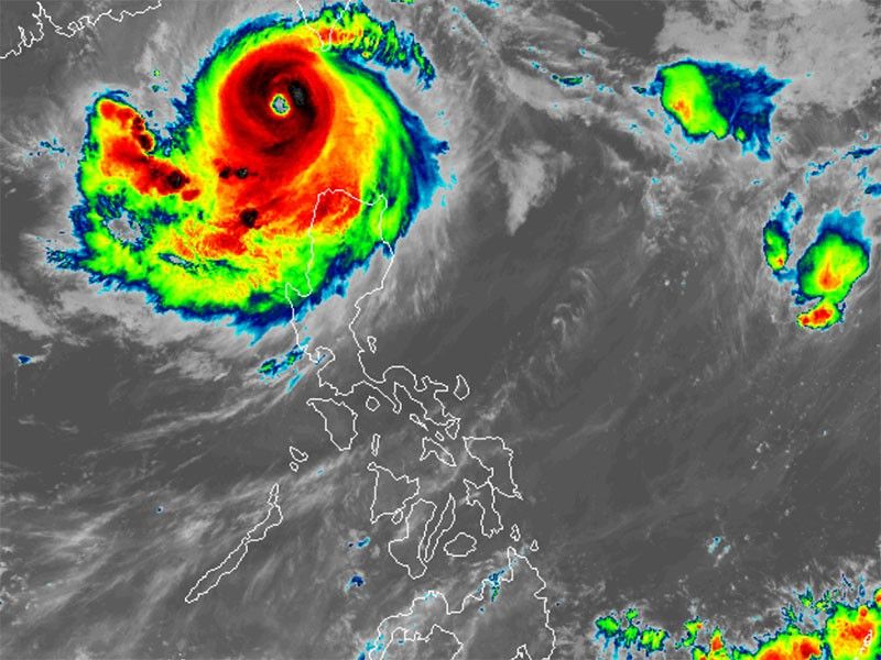
MANILA, Philippines — Tropical cyclone Julian (international name: Krathon) has intensified into a super typhoon early Tuesday morning, bringing powerful winds and heavy rains to northern Luzon.
As of 4 a.m., PAGASA said that Julian was located 205 kilometers west of Itbayat, Batanes.
Moving slowly west-northwest, it was carrying peak winds of 185 kilometers per hour (kph) near its center, with gustiness reaching 230 kph.
Wind signals
The state weather bureau raised tropical cyclone wind signals over the following areas.
- Babuyan Islands
- Ilocos Norte
- northern portion of Apayao (Calanasan, Luna)
- northwestern portion of mainland Cagayan (Santa Praxedes, Claveria, Sanchez-Mira, Abulug, Pamplona)
Residents of areas under Signal No. 2 could experience minor to moderate impacts from strong winds, with winds between 62 kph and 88 kph expected within at least 24 hours.
Signal No. 1
- Ilocos Sur
- La Union
- Pangasinan
- rest of Apayao
- Kalinga
- Abra
- Mountain Province
- Ifugao
- Benguet
- rest of mainland Cagayan
- Isabela, Quirino
- Nueva Vizcaya
- northern portion of Aurora (Dilasag, Casiguran, Dinalungan)
- northern portion of Nueva Ecija (Carranglan, Lupao, Pantabangan)
Heavy rainfall, severe winds
Heavy rains are expected over the Ilocos Region, Cordillera Administrative Region and northern parts of Cagayan and Isabela.
PAGASA advised residents of possible flash floods and landslides in the areas, especially in coastal and mountainous areas.
The state weather bureau also issued a warning for strong to gale-force gusts due to Super Typhoon Julian.
The following areas will be particularly affected by the strong winds:
- Tuesday, October 1: Ilocos Region, Cordillera Administrative Region, the northern and eastern portions of mainland Cagayan, the eastern portion of Isabela, Aurora, Zambales, Bataan, Metro Manila, CALABARZON, Romblon, and Camarines Norte
- Wednesday, October 2: Ilocos Norte, Ilocos Sur, Abra, Apayao, Batanes, Babuyan Islands, northern and eastern portions of mainland Cagayan and eastern portion of Isabela
- Thursday, October 3: Batanes and Babuyan Islands
Storm surges, sea conditions
PAGASA said there is a moderate to high risk of storm surges in low-lying coastal areas of Batanes and Babuyan Islands.
The state weather bureau also warned mariners of hazardous sea conditions and risky travel for small vessels, including motorbancas in the following areas
- Batanes: Up to 7 meters (high seas)
- Babuyan Islands and Ilocos Norte: Up to 6 meters (very rough seas)
- northern Ilocos Sur: Up to 4.5 meters (very rough seas)
- mainland Cagayan: Up to 3.5 meters (moderate to rough seas)
- Ilocos Region and seaboard of Isabela: Up to 3 meters (moderate to rough seas)
- northern Aurora and northern Zambales: Up to 2.5 meters (moderate to rough seas)
Track outlook
Super Typhoon Julian is expected to continue its slow movement towards the waters southwest of Taiwan.
A landfall along Taiwan's southwestern coast by Wednesday is expected, with the weather disturbance weakening slightly as it traverses Taiwan’s mountainous terrain.


- Latest
- Trending


