


LPA develops into Tropical Depression Enteng
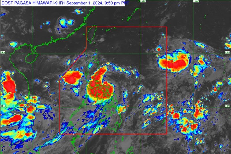
MANILA, Philippines — The Philippine Atmospheric, Geophysical and Astronomical Services Administration (PAGASA) yesterday said the low-pressure area (LPA) east of Eastern Visayas has developed into a tropical depression named Enteng.
At a press conference, PAGASA weather specialist Veronica Torres said the LPA turned into a tropical depression at 8 a.m. yesterday.
Torres said that Tropical Depression Enteng was located 120 kilometers north-northeast of Borongan City in Eastern Samar or 150 km east of Catarman, Northern Samar. It has maximum sustained winds of 45 km per hour near the center and gustiness of up to 55 kph as it moves northwestward at 30 kph.
“Tropical Depression Enteng is moving fast so we expect it after 24 hours or at 8 a.m. (today) to be located 190 km east of Baler, Aurora. At 8 a.m. (of Tuesday) at 145 km east of Aparri, Cagayan and at 8 a.m. (of Wednesday) in the vicinity of Calayan, Cagayan, Babuyan Island,” Torres said.
Torres said Enteng might reach tropical storm category by Tuesday and severe tropical storm category by Thursday.
“We do not discount the possibility that it will make landfall within the Bicol and Eastern Visayas region in the next 48 hours,” she added.
As of yesterday, the Manila International Airport Authority said six domestic flights were cancelled due to bad weather conditions at their destinations.
CebGo, a sister company of Cebu Pacific, also cancelled the flights to and from Masbate and Naga city.
Under PAGASA’s tropical cyclone wind signal system, a super typhoon is declared if it has sustained winds of 185 kph; typhoon for 118 to 184 kph; severe tropical storm for 89 to 117 kph; tropical storm for 62 to 88 kph and tropical depression if it has 61 kph or less.
Torres said that tropical cyclone wind signal No. 2 might be raised in areas affected by the tropical depression.
She said that tropical cyclone wind signal No. 1 was already raised in the eastern portion of Camarines Sur – including Presentacion, Garchitorena, Caramoan, Calabanga, Naga City, Pili, Bombon, Magarao, Ocampo, Baao, Nabua, Bula, Balatan, Bato, Milaor, Minalabac, Camaligan, Sagnay, Iriga City, Buhi, Tigaon, San Jose, Goa, Siruma, Tinambac, Lagonoy, Canaman, Gainza and San Fernando – and in Catanduanes, Albay, Sorsogon, Burias Island and Ticao Island.
Tropical cyclone wind signal No. 1 was also hoisted in Northern Samar, Samar, Eastern Samar, Biliran, and the northeastern portion of Leyte, including Babatngon, San Miguel, Tacloban City, Alangalang, Santa Fe, Palo and Barugo.
“Tropical Depression Enteng will bring strong rains. Southwest monsoon will also continue to affect many areas,” Torres said.
According to Torres, 100 to 200 millimeters (mm) of rain are to be expected in Camarines Sur, Albay, Sorsogon, Masbate, Northern Samar, Samar, Eastern Samar and Biliran yesterday.
She added that 100 to 200 mm of rain may also affect Isabela and Babuyan Islands today and tomorrow, respectively due to Enteng.
The tropical depression was also expected to bring rains from 50 to 100 mm in Quezon, Marinduque, Romblon and the rest of Eastern Visayas yesterday.
Torres said 50 to 100 mm of rains are to be expected in Cagayan, Quirino, Apayao, Kalinga, Mountain Province, Ifugao, Abra, Ilocos Norte and Ilocos Sur provinces today and tomorrow.
PAGASA is also expecting two to three typhoons to enter the Philippine area of responsibility this month.
“Usually, in the last quarter of the year, typhoons make landfall. For October, we expect two to three typhoons and for November and December, one to two typhoons,” Torres said.


- Latest
- Trending


