Signal No. 1 up in eastern Luzon as Typhoon Carina maintains strength

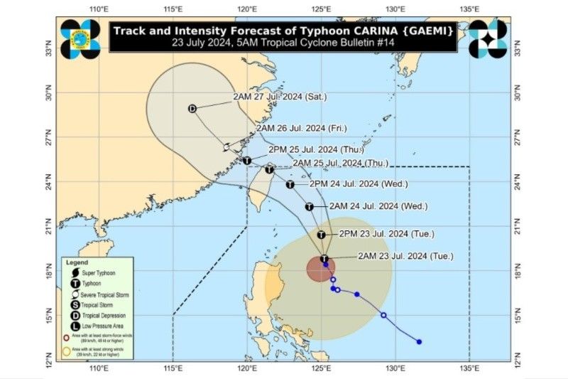
MANILA, Philippines — Typhoon Carina (international name: Gaemi) is far from land but has maintained its strength as it moves over the Philippine Sea early Tuesday, according to state weather bureau PAGASA’s 5 a.m. bulletin.
As of 4 a.m., the center of Typhoon Carina was estimated to be 380 kilometers east of Aparri, Cagayan, packing maximum sustained winds of 130 km per hour near the center with gustiness of up to 160 kph.
The typhoon is currently moving north-northwestward at 10 kph.
While not making a landfall in the Philippines while within the country’s jurisdiction, Carina is expected to enhance the southwest monsoon, or habagat. This triggers heavy rainfall over the western portion of Luzon.
Floods and rain-induced landslides are hazards in vulnerable areas.
PAGASA has raised Tropical Cyclone Wind Signal No. 1 over several areas in Luzon, warning of strong winds between 39-61 kph within the next 36 hours.
These areas are:
- Batanes
- Babuyan Islands
- Northern and eastern portions of mainland Cagayan
- Eastern portion of Isabela
- Northern portion of Apayao
- Northern portion of Ilocos Norte
- Northern portion of Aurora
- Polillo Islands
- Calaguas Islands
- Northern portion of Catanduanes
Carina will likely exit the Philippine area of responsibility on Thursday morning, but after it makes a landfall over the northern portion of Taiwan.
- Latest
- Trending


