


Tropical Storm Carina intensifies; heavy rains expected
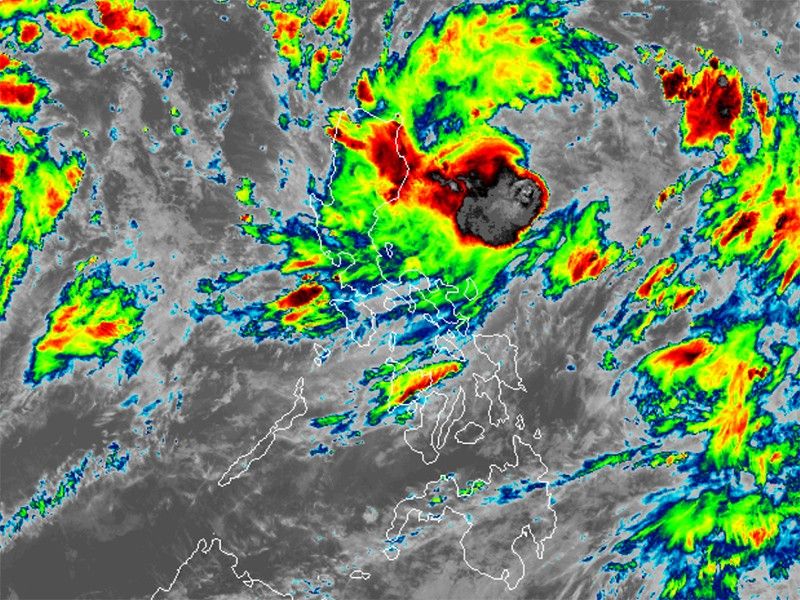
MANILA, Philippines — Tropical Storm Carina (international name: Gaemi) has slightly intensified as it continues to traverse the Philippine Sea on Sunday.
Carina was last located 350 kilometers east of Casiguran, Aurora, carrying peak winds of 85 kilometers per hour near the center, gustiness of up to 115 kph and central pressure of 996 hPa.
The storm is moving westward at 20 kph, with strong to gale-force winds extending up to 320 kilometers from the center.
Rainfall forecast
No wind signals have been hoisted.
But PAGASA warned of heavy rainfall, "potentially leading to flooding and landslides, especially in elevated or mountainous regions." The projected rainfall is as follows:
- Sunday to Monday noon (July 22): 50-100 mm over mainland Cagayan and Babuyan Islands.
- Monday noon to Tuesday noon (July 23): 100-200 mm over Batanes, and 50-100 mm over Babuyan Islands and mainland Cagayan.
- Tuesday noon (July 23) to Wednesday noon (July 24): 100-200 mm over Batanes, and 50-100 mm over Babuyan Islands.
Severe winds
Wind Signal No. 1 might be raised over extreme northern Luzon and northeastern Cagayan by Sunday night or Monday.
The enhanced southwest monsoon, influenced by Carina and Tropical Depression Butchoy, is expected to bring strong to gale-force gusts from Sunday until Wednesday over the following areas:
- Sunday (July 21) to Sunday noon (July 22): MIMAROPA, Bicol Region, and Western Visayas
- Monday noon (July 22) to Tuesday noon (July 23): Zambales, Bataan, Metro Manila, CALABARZON, MIMAROPA, Bicol Region, and Visayas
- Tuesday noon (July 23) to Wednesday noon (July 24): Ilocos Region, Central Luzon, Metro Manila, CALABARZON, MIMAROPA, Bicol Region, and Visayas.
In the next 24 hours, Carina and the enhanced southwest monsoon will cause moderate seas over the coastal waters of northern Luzon (1.0-2.5 meters), central and southern Luzon’s western seaboards (1.5-2.5 meters), and the eastern seaboard of the country (1.0-2.5 meters).
"Mariners using small vessels are advised to take precautionary measures and avoid sailing under these conditions," PAGASA said.
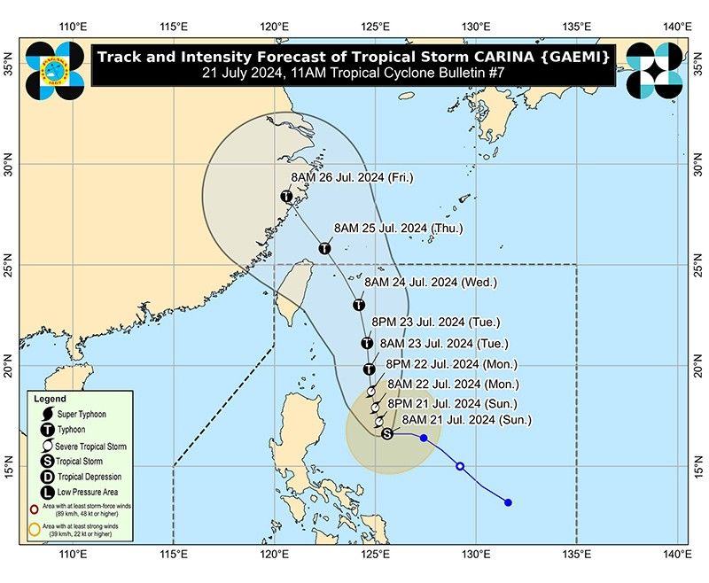
Track outlook
Carina is expected to move north-northwestward until Tuesday, staying far from the Philippine landmass.
"It is forecast to become a severe tropical storm by tonight (Sunday night) and reach typhoon category tomorrow (Monday) evening," PAGASA said.
"Rapid intensification within the forecast period is possible," it added.
It is expected to exit the Philippine Area of Responsibility (PAR) by Wednesday night or early Thursday, then approach the Ryukyu archipelago and move northwest over the East China Sea.
Carina is the third tropical cyclone to enter the Philippine Area of Responsibility this year.
Forecast position
- July 21, 2024 8:00 a.m.: 555 km east of Tuguegarao City, Cagayan
- July 21, 2024 08:00 p.m.: 495 km east of Tuguegarao City, Cagayan
- July 22, 2024 08:00 a.m.: 480 km east of Calayan, Cagayan
- July 22, 2024 08:00 p.m.: 390 km east of Basco, Batanes
- July 23, 2024 08:00 a.m.: 390 km east northeast of Basco, Batanes
- July 23, 2024 08:00 p.m.: 440 km northeast of Itbayat, Batanes
- July 24, 2024 08:00 p.m.: 640 km north northeast of Itbayat, Batanes (outside PAR)
- July 25, 2024 08:00 p.m.: 860 km north of extreme northern Luzon (outside PAR)


- Latest
- Trending


