Signal No. 2 raised in parts of CALABARZON due to 'Aghon'
MANILA, Philippines — State weather bureau PAGASA hoisted Tropical Cyclone Wind Signal (TCWS) No. 2 over parts of CALABARZON on Sunday morning due to Tropical Storm Aghon, which was last spotted over Quezon province.
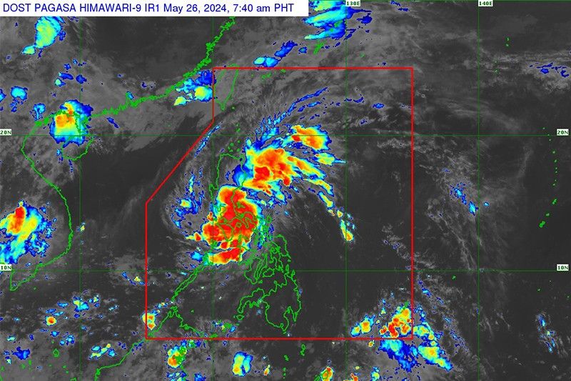
Aghon was located in the vicinity of Dolores town, packing maximum sustained winds of 65 kilometers per hour near the center and gusts of up to 80 kph. It was moving 15 kph.
PAGASA raised wind signals over the following areas:
Signal No. 2
- Northern and central portions of Quezon (Alabat, Perez, Quezon, Gumaca, Lopez, Macalelon, General Luna, Unisan, Pitogo, Plaridel, Agdangan, Padre Burgos, Atimonan, Mauban, Real, General Nakar, Infanta, Sampaloc, Pagbilao, Calauag, Lucban, City of Tayabas, Lucena City, Tiaong, Candelaria, Sariaya, Dolores, San Antonio) including Polillo Islands
- Laguna
- Eastern portion of Rizal (Jala-Jala, Pililla, Tanay)
- Eastern portion of Batangas (City of Tanauan, San Jose, Lipa City, Mataasnakahoy, Balete, Malvar, Santo Tomas, Cuenca, San Pascual, Batangas City, Ibaan, Padre Garcia, Rosario, San Juan, Taysan, Lobo)
Residents of areas under Signal No. 2 could experience minor to moderate impacts from strong winds.
Signal No. 1
- Southeastern portion of Isabela (Palanan, Dinapigue)
- Southern portion of Quirino (Maddela, Nagtipunan)
- Southern portion of Nueva Vizcaya (Alfonso Castaneda)
- Eastern and southern portions of Nueva Ecija (General Tinio, Gabaldon, Bongabon, Pantabangan, Rizal, General Mamerto Natividad, Laur, Palayan City, Peñaranda, San Leonardo, City of Gapan, Cabanatuan City, Santa Rosa, San Isidro, Cabiao, San Antonio, Jaen)
- Aurora
- Eastern portion of Pampanga (Candaba, San Luis, San Simon, Apalit, Santa Ana, Arayat)
- Bulacan
- Metro Manila
- Rest of Quezon
- Rest of Rizal, Cavite
- Rest of Batangas
- Northern portion of Oriental Mindoro (Pinamalayan, Pola, Naujan, Victoria, Socorro, City of Calapan, Bansud, Gloria, Baco, San Teodoro, Puerto Galera, Bongabong, Roxas)
- Marinduque
- Romblon
- Camarines Norte
- Camarines Sur
- Northern portion of Albay (Tiwi, Polangui, Malinao, Libon, Oas, City of Ligao)
- Burias Island
Residents of areas under Signal No. 1 could experience minimal to minor impacts from strong winds.
What to expect
PAGASA said that Aghon could bring rain of up to 200 millimeters over Quezon province, and between 100 and 200 mm over Aurora, eastern portion of Bulacan, Rizal, Laguna, Metro Manila and Camarines Norte today.
Meanwhile, eastern portion of Isabela, Nueva Ecija, rest of Bulacan, eastern portion of Pampanga, rest of CALABARZON, Oriental Mindoro, Occidental Mindoro, Romblon, Burias Island, western portion of Camarines Sur, Cuyo Islands, Aklan and Antique will have 50 to 100 mm of rainfall.
The state weather bureau warned of higher rainfall in elevated or mountainous areas. This can lead to flooding and landslides, especially in areas susceptible to these hazards or places that have experienced recent heavy rain.
PAGASA also said that there is a minimal to moderate risk of storm surge over the exposed and low-lying coastal areas of Cagayan, Isabela, Aurora, Central Luzon, Metro Manila, CALABARZON, Mindoro provinces, Marinduque, Romblon, Camarines Norte, Camarines Sur, western coast of Albay, Burias Island, northwest coast of mainland Masbate and Aklan.
Sea travel is risky for small seacrafts, including all motor bancas, over the coastal waters of Marinduque and Quezon province, southern coastal waters of Batangas, and northern coastal waters of Camarines Norte.
Aghon will traverse the landmass of mainland CALABARZON and Polillo Islands, and will move over the waters off the east coast of Quezon province or Aurora by Sunday evening or early Monday morning.
"During this period, Aghon will likely remain as a tropical storm although weakening into a tropical depression while over mainland CALABARZON is not ruled out due to land interaction," PAGASA said.
Aghon will gradually accelerate northeastward while intensifying from Monday through the remainder of the forecast period. It is forecast to reach severe tropical storm category on Tuesday.
PAGASA is not ruling out the possibility of Aghon becoming a typhoon within the Philippine Area of Responsibility (PAR), although it will most likely happen far from the landmass.
Aghon may exit the PAR region on Wednesday.
Forecast position
- May 26, 2024 5:00 PM - 5 km north northeast of Infanta, Quezon
- May 27, 2024 5:00 AM - 65 km southeast of Casiguran, Aurora
- May 27, 2024 5:00 PM - 220 km east of Tuguegarao City, Cagayan
- May 28, 2024 5:00 AM - 405 km east of Calayan, Cagayan
- May 28, 2024 5:00 PM - 640 km east northeast of Itbayat, Batanes
- May 29, 2024 5:00 AM - 1,125 km east northeast of Extreme Northern Luzon (outside PAR)
- May 30, 2024 5:00 AM - 2,150 km east northeast of Extreme Northern Luzon (outside PAR)
— Gaea Katreena Cabico


- Latest
- Trending