Brace for Goring, LGUs told
Thousands flee super typhoon
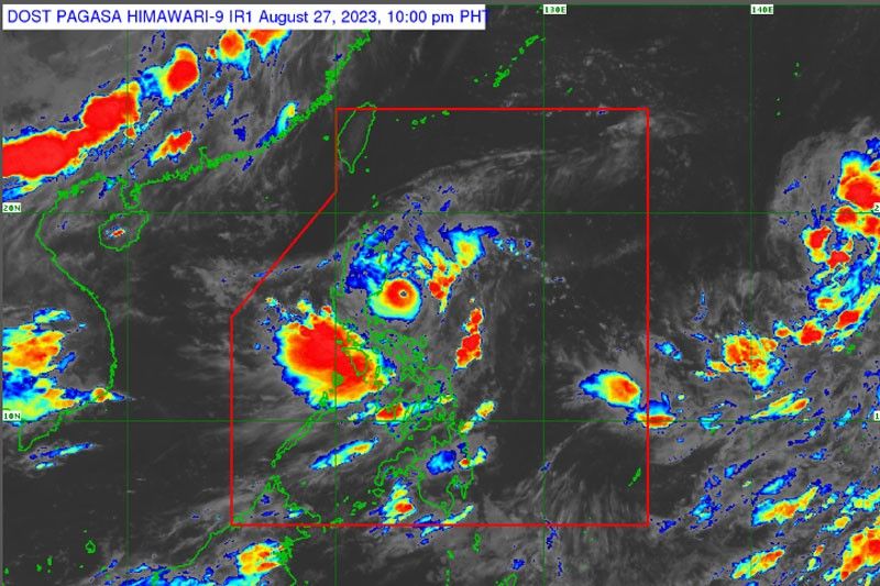
MANILA, Philippines — Goring has further strengthened into a super typhoon, while a low-pressure area (LPA) outside the Philippine area of responsibility has developed into a tropical depression, the Philippine Atmospheric, Geophysical and Astronomical Services Administration (PAGASA) said yesterday.
Interior and Local Government Secretary Benhur Abalos has ordered all concerned local government units (LGUs) to ensure their preparedness amid the dangers posed by Goring.
At a press briefing, PAGASA weather specialist Aldczar Aurelio said that Goring (international name Saola) will also enhance the southwest monsoon affecting the entire country.
“Super Typhoon Goring persists in strength while moving south-southeastward, east-northeast of Casiguran, Aurora. The center of the eye of super typhoon Goring was located at 95 kilometers (km) east of Casiguran, Aurora with maximum sustained winds of 185 km per hour near the center with gustiness of up to 230 km per hour,” Aurelio said.
Aurelio added that wind signal number 3 was hoisted in the eastern portion of Isabela, including Divilacan, Palanan, Dinapigue; and the extreme northern portion of Aurora.
He added that wind signal number 2, meanwhile, was raised in the eastern portion of mainland Cagayan, including Peñablanca, Baggao, Gattaran, Lal-Lo, Gonzaga, Santa Teresita, Buguey, Santa Ana, Enrile and Tuguegarao City; northern and central portion of Isabela, including Maconacon, Cabagan, Tumauini, San Pablo, Benito Soliven, San Guillermo, Jones, Echague, San Agustin, Angadanan, Cauayan City, Naguilian, Gamu, Santa Maria, Santo Tomas, Delfin Albano, Quirino, Burgos, Reina Mercedes, Alicia, Luna, Quezon, Mallig, Roxas, San Manuel, Aurora, Cabatuan, San Mateo and San Isidro; extreme northern portion of Aurora, including Casiguran, Dinalungan and Dilasag; and the eastern portion of Quirino.
Aurelio said that wind signal number 1 was also raised in Batanes, the rest of Cagayan including Babuyan Islands, the rest of Aurora, the rest of Quirino, the rest of Isabela, Apayao, Nueva Vizcaya, Ifugao, Mountain Province, Kalinga, Abra, eastern portion of Ilocos Norte, including Pagudpud, Adams, Vintar, Carasi, Nueva Era, Banna, Marcos, Dingras, Solsona, Piddig, Dumalneg and Bangui; Pollilo Islands, eastern portion of Benguet, including Bokod, Buguias, Kabayan, Mankayan; eastern portion of Nueva Ecija, including Carranglan, Pantabangan, Bongabon, Gabaldon, Laur, Rizal; and Calaguas Islands.
Aurelio added that the tropical depression outside of PAR may enter late Wednesday or Thursday, and will be named “Hanna.”
“The center of the tropical depression outside PAR was located at 2,325 kms. east Central Luzon,” Aurelio said.
For his part, PAGASA assistant weather services chief Chris Perez said Goring will bring more than 200 millimeters of rainfall in the eastern portion of Isabela.
“Goring remains far from the landmass, but heavy clouds are currently affecting a big portion of northern Luzon. It also enhances the southwest monsoon, bringing rains in Central and Southern Luzon, and even the western section of Visayas and Zamboanga Peninsula,” Perez said.
“We expect 100 to 200 millimeters of rains in the eastern portion of Cagayan and the rest of the eastern portion of Isabela. On the other hand, 50 to 100 millimeters of rain are expected in the Ilocos Region, Apayao, Abra, Benguet, northern portion of Aurora, eastern portion of Nueva Vizcaya, the rest of Cagayan and the rest of Isabela,” he added.
Perez said that Goring will also bring rains in the eastern portion of the Babuyan Islands and eastern portion of mainland Cagayan.
He said that today, the enhanced southwest monsoon will bring 100 to 200 millimeters of rains in the western portion of the country, particularly Cavite, Batangas, the northern portion of Palawan, Cuyo Island, Antique, Zambales, Batanes and Occidental Mindoro.
Tomorrow, “the enhanced southwest monsoon will bring 50 to 100 millimeters of rains in Cavite, Batangas, Romblon, northwestern portion of Palawan, including Cuyo and Calamian Islands, Antique, Guimaras, northwestern portion of Aklan and 100 to 200 millimeters of rains in Zambales, Bataan and Occidental Mindoro,” Perez added.
He said that until Wednesday, concentration of rains brought by Goring will be in the eastern portion of Northern Luzon while areas affected by the enhanced southwest monsoon will be in Central and Southern Luzon and Visayas.
Perez said that by tomorrow, Goring will be located 340 kilometers of Calayan, Cagayan and by Wednesday morning, it is expected to be located at 75 kilometers east northeast of Itbayat, Batanes.
“By Thursday morning, Goring is expected to be in the boundary of PAR before it leaves PAR. By Friday morning, it is expected to be located outside PAR at 540 kilometers ng northwest ng Itbayat, Batanes,” he added.
According to Perez, rains will persist in Northern Luzon even after Goring exits PAR.
Abalos orders LGUs to prepare
In a memorandum, Abalos particularly tasked the local chief executives in the Cagayan Valley Region and in other affected regions to remain vigilant and carry out the necessary critical preparedness.
Abalos directed Region 2 to activate the Emergency Operations Center and Disaster Online Reporting and Monitoring System to ensure the adherence of LGUs within their jurisdiction.
He ordered concerned LGUs to convene their local disaster risk reduction and management councils (DRRMCs), conduct pre-disaster risk assessment for floods and other hazards, activate their barangay DRRMCs for early warning and monitoring of landslide zones and assess the structural integrity of evacuation areas.
“The safety of our people is primordial. Hence, affected LGUs must implement preemptive evacuation when necessary, prioritize the health and safety of all response personnel and evacuees and preposition supplies and equipment,” Abalos said.
Abalos said LGUs should continuously inform affected communities of situation updates and intensify the use of social media platforms for public information.
On the other hand, Abalos directed concerned LGUs to undertake necessary critical preparedness actions in 1,481 barangays from the Cordillera Administrative Region, Ilocos Region, Cagayan Valley, Central Luzon, CALABARZON, MIMAROPA, Western Visayas, and Zamboanga Peninsula.
The Mines and Geosciences Bureau has identified the 1,481 barangays to have high to very high susceptibility to floods and rain-induced landslides.
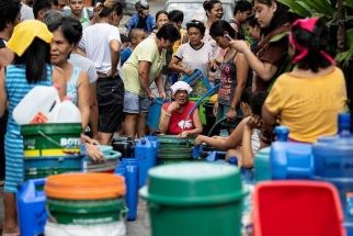
Thousands flee flooding
Residents of coastal communities vulnerable to high winds and large waves were moved to higher ground on Isabela province’s eastern or Pacific coast, as were those on the northern tip of Cagayan province to the north, and Ilocos Sur province on Luzon’s northwest coast, officials said.
“These coastal towns have no protection because they are directly facing the Pacific,” said Isabela rescue official Constante Foronda, putting the number of evacuees in Isabela at 372.
In Cagayan, rescue official Ruelie Rapsing told AFP that 388 people were evacuated overnight amid flooding on several coastal municipalities on Luzon’s northeast tip.
The Office of Civil Defense also reported the evacuation of 421 people from four municipalities in Ilocos Sur, which were hit by a landslide, flooding and overflowing rivers.
Flight cancellations
The Civil Aviation Authority of the Philippines (CAAP) has prepared precautionary measures in anticipation of possible damage due to Goring.
Airports that may potentially be affected by Goring include Tuguegarao Airport, Basco Airport, Itbayat Airport, Cauayan Airport, and Palanan Airport.
Additionally, airports in Laoag, Vigan, and Baguio are also gearing up for possible harsh weather conditions.
In a progress report by Area 2 manager Mary Sulyn Sagorsor to CAAP director general Manuel Antonio Tamayo, all flights at Tuguegarao, Cauayan, Palanan and Basco Airports were cancelled.
Area 1 manager Ronald Estabillo reported that Laoag International Airport flights of Cebu Pacific (Mnl-Lao-Mnl) 5j404/405 were canceled due to bad weather. Baguio Airport flights of PALEx Ceb-Bag-Ceb flight 2P 2230/2231 were also cancelled.
PCG suspends sea travel
The Philippine Coast Guard (PCG) yesterday ordered the temporary suspension of sea travel of all types of vessels as a precaution against the effects of Goring.
Petty Officer First Class Rafael Pangilinan, PCG Northern Quezon acting station commander, issued a Notice to Mariners at 5 a.m. alerting those about to set sail that they are temporarily suspending travel.
“The PCG is temporarily suspending voyages of all vessels/watercrafts plying the route within the area of responsibility of Coast Guard Station Northern Quezon due to hoisting of Tropical Cyclone Wind Signal Number 1 for Typhoon ‘Goring’ over Polillo Group of Islands and the possible effect of the inclement weather,” Pangilinan said.
Government monitoring the situation
Meanwhile, President Marcos assured the public that the government has made preparations for the effects of Goring.
“The government is monitoring the situation in northern Luzon, which is again experiencing heavy rains and strong winds caused by typhoon #GoringPH,” the President said in an X post written in Filipino Saturday night.
Marcos said more than 10,000 food packs of the social welfare department have been prepositioned in affected areas, while disaster and response units are on standby for possible evacuation and rescue operations.
“We are also ensuring that the supply of food and non-food items are enough until the typhoon leaves the country,” he added. — Rudy Santos, Evelyn Macairan, Alexis Romero


- Latest
- Trending