Signal No. 3 hoisted over parts of Cagayan, Isabela due to 'Goring'
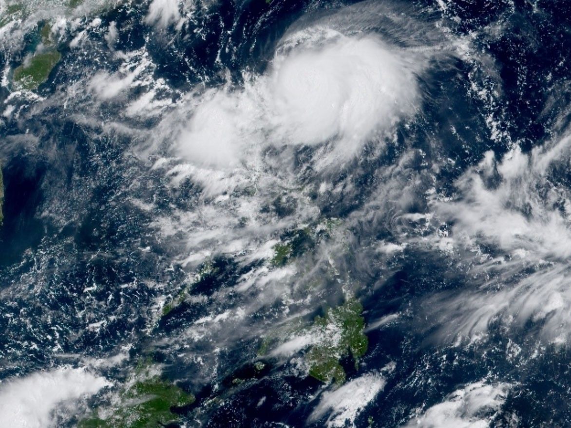
MANILA, Philippines — Typhoon Goring steadily intensified as it moved south southwestward over the sea east of Babuyan Islands, according to the last foreacast of the state weather bureau.
PAGASA said on Saturday that the center of the eye of Goring was last estimated at 155 kilometers east northeast of Aparri, Cagayan at around 10 a.m.
- Maximum sustained winds: 150 kilometers per hour near the center
- Gustiness: up to 185 kilometers per hour
- Direction: south southwestward
- Movement: 10 kilometers per hour
"Due to highly favorable environment, Goring is forecast steadily intensify throughout most of the forecast period and may reach super typhoon category on Monday," said PAGASA.
"Upwelling of cooler waters due to its slow movement will limit further intensification by late Monday or early Tuesday."
PAGASA predicted approximately 100-200 mm of rainfall for the eastern part of mainland Cagayan on Saturday.
Meanwhile, an estimated 50-100 mm of rainfall is expected across Babuyan Islands, the rest of mainland Cagayan, the eastern portion of Isabela, Cordillera Administrative Region, Ilocos Norte, and the northern portion of Aurora.
Forecast rainfall will generally be higher in elevated or mountainous areas. Due to this, flooding and rain-induced landslide are possible in areas that are susceptible to these hazards.
Storm signal warnings
Tropical Cyclone Wind Signals are in effect in various parts of Luzon on Saturday.
Signal No. 3
- northeastern portion of Cagayan (Santa Ana)
- extreme eastern portion of Isabela (Divilacan, Palanan)
Winds exceeding 62 kph and reaching up to 88 kph may occur within the next 24 hours.
Signal No. 2
- eastern portion of Isabela (Dinapigue, San Mariano, Ilagan City, Maconacon, Cabagan, Tumauini, San Pablo)
- eastern portion of Cagayan (Peñablanca, Baggao, Gattaran, Lal-Lo, Gonzaga, Santa Teresita, Buguey)
- northern portion of Aurora (Dilasag, Casiguran)
Within the next 24 hours, these areas could experience gale-force winds, posing a slight to moderate risk to both life and property.
Signal No. 1
- Batanes
- rest of Cagayan including Babuyan Islands
- central portion of Aurora (Dinalungan, Dipaculao)
- Quirino
- rest of Isabela
- Apayao
- eastern portion of Nueva Vizcaya (Kasibu, Quezon, Diadi, Bagabag, Solano, Villaverde)
- eastern portion of Ifugao (Lamut, Lagawe, Hingyon, Banaue, Mayoyao, Aguinaldo, Alfonso Lista)
- eastern portion of Mountain Province (Barlig, Natonin, Paracelis)
- Kalinga
Strong winds are anticipated in these areas over the next 36 hours, potentially posing a minor to moderate risk to both life and property.
"Goring is forecast to move generally southward to southwestward today until tomorrow, then will turn generally eastward to northeastward on Sunday," PAGASA said.
"Afterwards, the typhoon will exit its looping path and move northwestward on Tuesday towards the sea east of Taiwan while moving on a consistent pace."
Monsoon rains
The southwest monsoon (habagat) enhanced by Goring will bring occasional or monsoon rains over the western portions of central Luzon, southern Luzon and Visayas over the next three days.
The habagat will continue to bring gusty conditions over the following areas not under any wind signal, especially those in coastal, upland and mountainous areas exposed to winds: Aurora, Bataan, Metro Manila, CALABARZON, Bicol Region and most of MIMAROPA.


- Latest
- Trending