Tropical depression to enter Philippines Wednesday

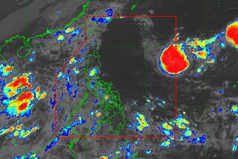
MANILA, Philippines — A low-pressure area (LPA) expected to enter the Philippine area of responsibility (PAR) near Mindanao last night may develop into the first tropical cyclone of the year by Wednesday, state weathermen said.
Once the LPA turns into a tropical depression, it will be named “Amang,” the first storm to enter the PAR amid the threat of an El Niño year.
In a radio interview yesterday, Philippine Atmospheric, Geophysical and Astronomical Services Administration (PAGASA) weather specialist Benison Estareja said the LPA will mainly affect Eastern Visayas, Surigao del Norte and Dinagat Island.
“By Tuesday until Friday, Eastern Visayas, Bicol region, Quezon, Surigao del Norte and Dinagat Islands may experience mostly cloudy skies with scattered rainshowers and thunderstorms as the weather system approaches,” PAGASA’s weekly weather outlook declared.
But Estareja said rains should also be expected in Eastern Visayas, Caraga and Bicol regions.
“Within 24 hours, there is a small chance that the LPA will develop into a typhoon but once it crosses the Philippine Sea in the coming days, there is still a chance. We are still not ruling out the possibility that it will become a tropical depression by the middle of the week,” he said.
“By Wednesday, the LPA will already affect Calabarzon, Metro Manila, and part of Central Luzon and the rains will persist until Friday,” he added.
He warned that even if the LPA does not develop into a tropical depression, residents in Southern Luzon and Visayas are likely to experience rainy days.
PAGASA said it expects at least one tropical cyclone in April; one to two each in May and June; and two to three each in July, August and September 2023.
Earlier, it said that El Niño will likely develop in the third quarter of the year and persist until 2024.
Subic heat index warning
Yesterday, PAGASA warned that the heat index in Subic, Zambales this week could reach 52 degrees Celsius as one of the effects of the dry season.
Based on its five-day forecast, the 52-degree-Celsius feel of heat in Subic is expected on Thursday, so residents are warned against heat stroke.
The weather bureau defines heat index as a measure of how hot it really feels outside, when humidity and other factors are considered along with the temperature.
The weather bureau warned that heat stroke is probable with continued exposure to heat index ranging from 42 to 52 degrees Celsius.
It advised the public to limit time spent outdoors, drink plenty of water, and avoid tea, coffee, soda and liquor. It also urged them to schedule heavy-duty activities to prevent heat-related illnesses.
Apart from Subic, a high heat index could also be felt on Thursday in other areas like Clark, Pampanga at 47 degrees Celsius; Coron, Palawan, Pili, Camarines Sur, Cabanatuan, Nueva Ecija, and Science Garden in Quezon City, 45 degrees Celsius; Catbalogan, Samar, Ninoy Aquino International Airport and Port Area, Manila, 44 degrees Celsius; and Iloilo and Sangley Point, Cavite, 42 degrees Celsius.
On Wednesday, Catbalogan, Samar could experience a heat index of 48 degrees Celsius, with areas in Tacloban City feeling the heat at 47 degrees Celsius and in Pili, Camarines Sur at 43 degrees Celsius.
This year, the highest heat index in the country was 47 degrees Celsius recorded in San Jose, Oriental Mindoro last March 25.
Adopt heat stress measures
Amid the scorching heat, the Department of Labor and Employers has ordered employers to adopt measures to prevent heat stress at the workplace.
In an advisory, Labor Secretary Bienvenido Laguesma noted that the Labor Code mandates employers to ensure the safety and health of workers from extreme heat.
Laguesma said employers and the workers may agree to adopt a flexible work arrangement to limit exposure to extreme heat and strenuous activities.
He said work hours may be adjusted while maintaining the total number of work hours within the day or week “until such time that the weather condition has improved.” — Mayen Jaymalin
- Latest
- Trending


