'Fabian' slowly moving west, seen out of PAR by Saturday
MANILA, Philippines — After maintaining its strength for most of Thursday morning, Typhoon Fabian (In-fa) was stationary for a time and is now slowly moving westward, state weather bureau PAGASA said.
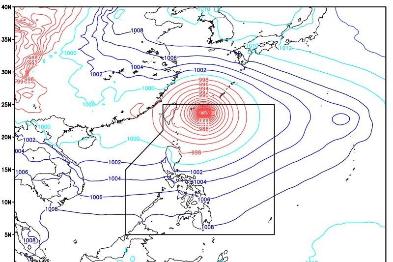
Per PAGASA's latest weather bulletin 5 p.m. Thursday, Fabian was last seen 505 kilometes northeast of Itbayat, Batanes packing winds of up to 150 kilometers per hour near the center and gustiness of up to 185 kph.
As a result, the rains affecting most of the country are caused by the southwest monsoon or habagat.
Fabian is forecast to exit the Philippine Area of Responsibility Friday evening or Saturday.
"Moderate to strong winds blowing from the Southwest will prevail over the rest of Northern Luzon and in Aurora Province. The coastal waters will be rough to very rough," PAGASA also said.
READ: 'Fabian' maintains strength, seen out of PAR by Saturday
What to expect
According to PAGASA, Occidental Mindoro and northern Palawan, including Calamian Islands will have monsoon rains. Batanes and Babuyan Islands continue to face rains with gusty winds due to Fabian coupled with the southwest monsoon.
PAGASA warned of "possible flash floods or landslides due to moderate to at times heavy rains [and] possible very light to light to damage to structures and vegetation due to moderate to strong winds" in these areas.
Western Visayas and the rest of Palawan including Kalayaan Islands will have cloudy skies with scattered rain showers and thunderstorms and while the rest of Visayas will have partly cloudy to cloudy skies with rain showers or thunderstorms due to the Southwest Monsoon.
PAGASA added that monsoon rains will be experienced over the provinces of:
- Ilocos Norte
- Ilocos Sur
- La Union
- Pangasinan
- Abra,
- and Benguet
Cloudy skies with scattered rain showers and thunderstorms are also expected over:
- mainland Cagayan,
- Isabela,
- Quirino,
- Nueva Vizcaya,
- Aurora,
- Apayao,
- Kalinga,
- Mountain Province,
- and Ifugao
Metro Manila, Ilocos Region, MIMAROPA, Benguet, Abra, Zambales, Bataan, Tarlac, Pampanga, Bulacan, Rizal, Laguna, Cavite and Batangas face monsoon rains.
Possible impacts in these areas, according to Pagasa, include "flash floods or landslides due to scattered to widespread moderate to at times heavy rains."
The rest of the country is projected to face "partly cloudy to cloudy skies with rain showers or thunderstorms."


- Latest
- Trending