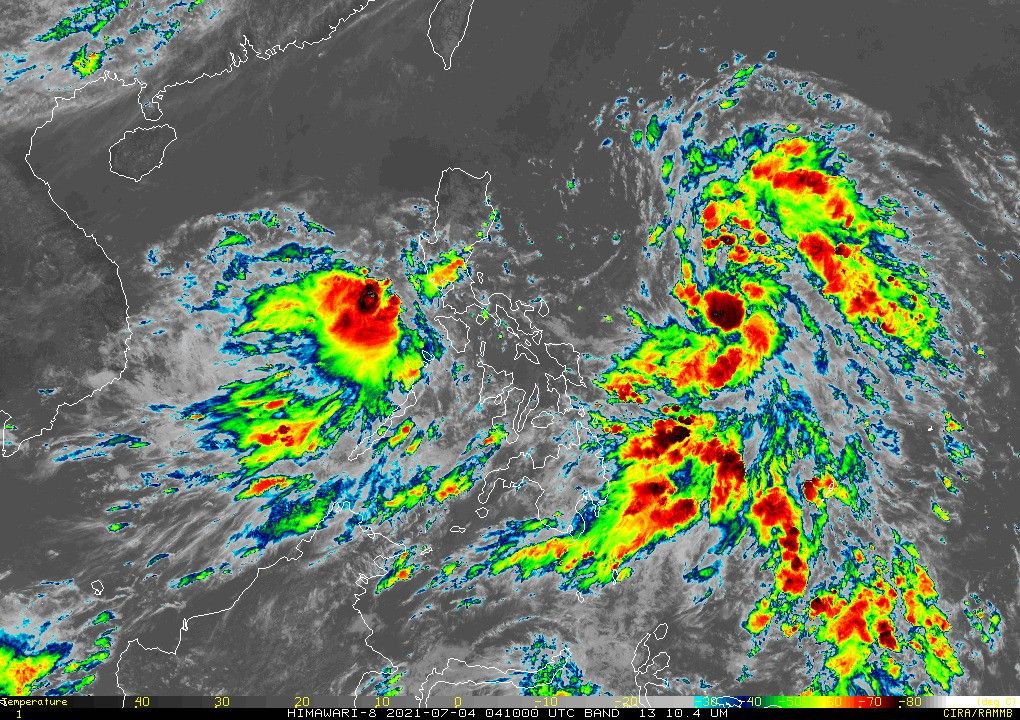
Signal No. 1 up in Batanes, Cagayan due to 'Emong'

MANILA, Philippines — Weather bureau PAGASA on Sunday said the low pressure area seen over Eastern Samar has developed into a tropical depression at around 8 a.m., with storm signals up in select areas.
The agency in a bulletin said Tropical Depression "Emong" was spotted at 700 kilometers east northeast of Guian, or 790 km east of Catarman in Northern Samar.
Currently, it packs 45 kilometers per hour maximum sustained winds, and gustiness of up to 55 kph.
The sixth storm to enter the Philippines this year has a speed of 25 kph, and moves at a northwestward direction.
As of 11:00 a.m. of July 4, these areas are under Signal No. 1:
- Batanes
- northeastern portion of Cagayan (Santa Ana, Gonzaga) including Babuyan Islands
PAGASA said Emong is likely to remain a tropical depression throughout its forecast period.
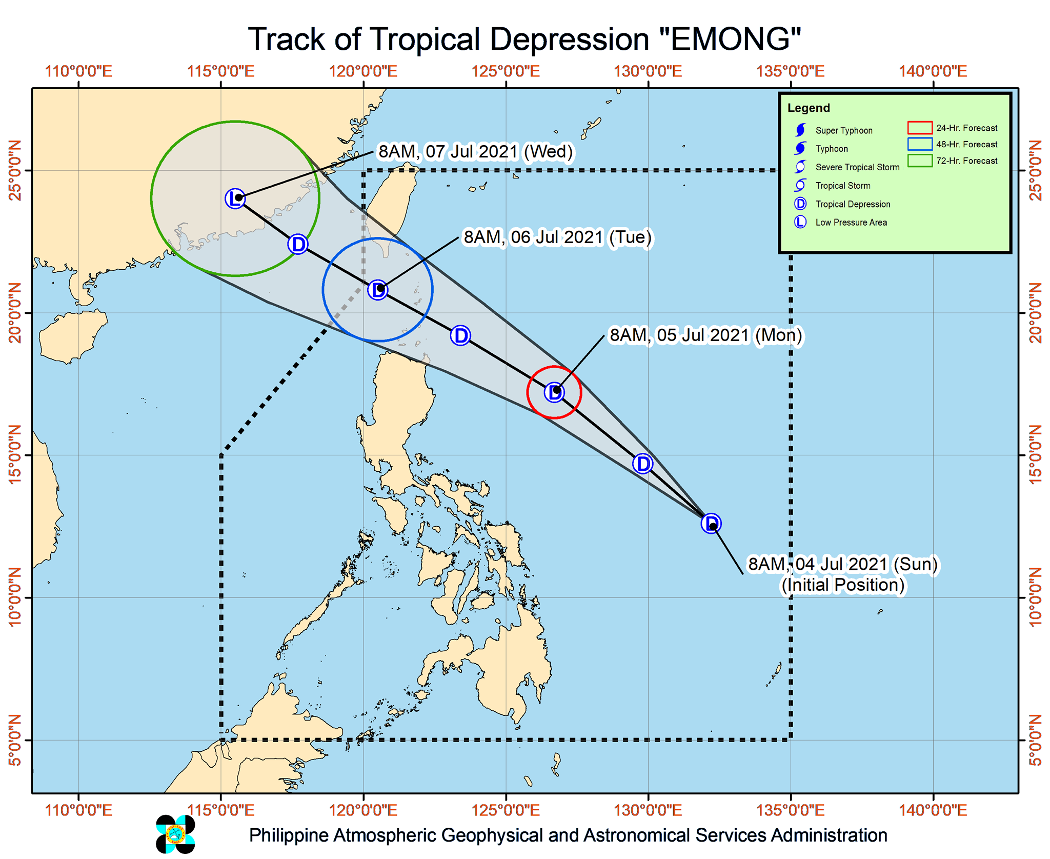
It will also keep its direction until Monday morning, its center forecast to traverse Batanes-Babuyan Islands area by Monday evening and Tuesday morning.
"Considering these developments, the public and disaster risk reduction and management offices concerned are advised to take all necessary measures to protect life and property," PAGASA said.
The agency warned those living in areas highly or very highly susceptible to hazards to follow evacuation and other instructions from their local officials.
Emong was among the two low pressure areas PAGASA was monitoring this morning.
The second LPA, it said, was last seen in the vicinity of Calapan City in Oriental Mindoro. It is less likely to develop into a tropical depression within 24 hours.
Its effect along with that of the Southwest Monsoon will bring light to moderate with at times heavy rains over Bulacan, Pampanga, Nueva Ecija, Zambales, Bataan, Metro Manila, Rizal, northern Quezon including Polilio Islands, Laguna, Cavite, Batangas, Palawan including Calamian Islands, Mindoro Provinces and Antique.
Forecast Position
- Monday morning: 530 km east of Tuguegarao City, Cagayan
- Tuesday morning: 140 km west of Itbayat, Batanes
- Wednesday morning: 745 km west northwest of Itbayat, Batanes

Follow this page for updates on Emong, the fifth tropical cyclone to enter the Philippines on 2021. — Main photo from JMA
Tropical Depression Emong has passed very close to Batan and Sabtang Islands, state weather bureau PAGASA says Monday night.
The weather disturbance will bring moderate to heavy with at times intense rains over Batanes and Babuyan Islands from Monday night through Tuesday morning.
At 7 p.m., Emong was located 90 km west of Basco, Batanes with winds of 55 kph and gusts of 70 kph. It is moving northwestward at 50 kph.
Batanes, and portions of Cagayan (Santa Ana and Gonzaga) including Babuyan Islands remain under Tropical Cyclone Wind Signal no. 1 as Tropical Depression Emong accelerates.
The tropical cyclone continues to approach the Batanes-Babuyan Islands area and is forecast to bring moderate to heavy with at times intense rains over the area.
At 4 p.m., Emong was located 215 km east northeast of Calayan, Cagayan or 160 km east southeast of Basco, Batanes with winds of 55 kph and gustiness of 702 kph. It is moving northwestward at 45 kph.
Tropical Depression Emong slightly intensifies as it moves north-northwestward over the Philippine Sea.
Signal No. 1 is still up over Batanes and the northeastern portion of Cagayan (Santa Ana, Gonzaga) including Babuyan Islands. This means that winds of 30 to 60 kph may be expected in at least 36 hours.
At 4 p.m., Emong was located 780 km east of Virac, Catanduanes with winds of 55 kph and gusts of up to 70 kph. It is moving northwestward at 25 kph.
TROPICAL CYCLONE BULLETIN NO. 2
— PAGASA-DOST (@dost_pagasa) July 4, 2021
Tropical Depression “#EmongPH”
Issued at 5PM 04 July 2021
Valid for broadcast until the next bulletin at 11PM today.
TROPICAL DEPRESSION “EMONG” SLIGHTLY INTENSIFIES WHILE MOVING NORTH-NORTHWESTWARD OVER THE PHILIPPINE SEA EAST OF SOUTHERN LUZON. pic.twitter.com/ewaYTwguMq
Signal No. 1 is hoisted over Batanes and some localities in Cagayan including Babuyan Islands in anticipation of the arrival of strong winds caused by Tropical Depression Emong.
At 10 a.m., Emong was located 700 km east northeast of Guiuan, Eastern Samar or 790 east of Catarman, Northern Samar.
The weather disturbance has winds of 45 kph and gusts of 55 kph. It is moving northwestward at 25 kph.
As of 8 a.m., the low pressure area east of Guiuan, Eastern Samar has developed into a tropical depression, state weather bureau PAGASA says.
The weather disturbance will be called Emong, the fifth tropical cyclone to enter the country this year.
- Latest
- Trending


