'Liwayway' strengthens into typhoon, to exit PAR Thursday

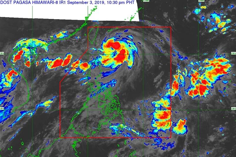
MANILA, Philippines — "Liwayway" has intensified from a severe tropical storm into a typhoon, the latest severe weather bulletin of PAGASA showed Tuesday.
As of the 11 p.m. bulletin, the state weather bureau said "Liwayway" now packs maximum sustained winds of up to 120 kph from the 110 kph recorded at 5 p.m. Meanwhile, its gustiness was at 150 kph from the previous 135 kph.
A landfall scenario is still not expected for the typhoon which is moving north-northeast at 10 kph and is forecast to exit the Philippine area of responsibility on Thursday between afternoon and evening.
The eye of the typhoon was located 265 km east-northeast of Batanes, where Signal No. 1 remains raised.
PAGASA warned that sea travel is risky over the seaboards of Luzon, including those under Signal No.1, due to potentially rough sea conditions.
State weather forecasters said "Liwayway" is expected to bring light to moderate with intermittent heavy rains over Batanes and Babuyan Islands between Tuesday evening to Wednesday evening. The southwest monsoon or habagat is also forecast to bring scattered light to moderate rains, with at times heavy rain showers during thunderstorms, over Ilocos, Cordillera Administrative Region, Central Luzon, Calabarzon, Metro Manila, northern portions of Palawan including Calamian Islands and Mindoro Provinces.
Meanwhile, between Wednesday evening and Thursday evening, the trough of the typhoon and the habagat is seen to bring light to moderate with intermittent heavy rains over Batanes and Babuyan Islands.
PAGASA said residents in areas affected by the typhoon should take precautionary measures, coordinate with local disaster risk reduction and management offices and continue monitoring for updates, especially the bureau's thunderstorm advisories and heavy rainfall warnings.
- Latest
- Trending


