Holy grail of Philippine maps surfaces at auction

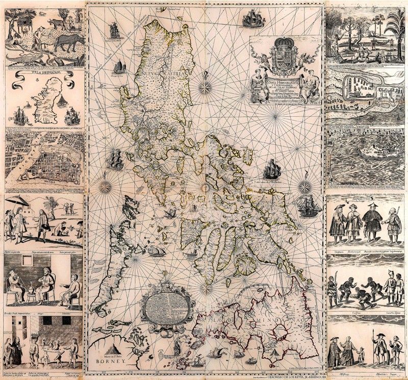
MANILA, Philippines — The “Holy Grail” of Philippine maps, the Murillo Velarde Map of 1734, has surfaced at León Gallery as an important highlight of its Magnificent September Auction on Sept. 14.
The map is certainly the country’s most famous as a result of the submission of one other copy to the Permanent Court of Arbitration in The Hague on the matter of Panatag or Scarborough Shoal, shown as “Panacot” on the map.
The seminal work “Philippine Cartography 1320 – 1899,” recently edited by Dr. Carlos Madrid, declared how this landmark map “became the iconic representation of the historical position of the Philippine republic, thus imbuing the map with inordinate importance and international relevance.”
Furthermore, Dr. Madrid emphasized, “the court clearly affirmed that historical cartography evidences a connection between Scarborough Shoal and the Philippine mainland.”
Jaime Ponce de Leon, director of León Gallery, said that he had been in pursuit of the Murillo Velarde Map of 1734 from “a very distinguished private collector” for several years. It was only this year, however, that the owner finally decided to share it with the collecting world and send it to a new home.
The Murillo Velarde Map is historically important not only because it influenced several generations of the world’s map-makers but also provided an important record of the Philippines, its seas and moreover, the people of our country. It was also the culmination of two centuries of map-making and was the most accurate till then and long after.
According to the “Mapping the Philippine Seas” catalogue, produced by the Philippine Map Collectors Society, the map “shows coasts, towns and interior topography, and is also a sea chart with a stylized sun as the center point and four compass roses at the cardinal points of the hidden circle formed by intersecting rhumb lines. Two tracks for the Manila Galleon are shown, one around the north of Luzon and the other through the San Bernardino Strait, as well as the routes taken by Ferdinand Magellan and for trading with China.”
The entire work was engraved and printed by Nicolas de la Cruz Bagay, who was responsible for producing some two dozen books for the Jesuits in the Philippines. Other illustrations were intricately drawn by Francisco Suarez. Both he and De la Cruz Bagay signed and described themselves as “Indio Tagalog.”
Moreover, it is “not only the map’s size, accuracy, detail and aesthetics but also its twelve exquisite engravings to be found on its two side panels.”
It is these vignettes or ‘tarjetones’ that make the complete Murillo map a marvel to behold. They illustrate the various inhabitants of these islands, country life, exotic animals such as bats, crocodiles and snakes, as well as the plans of Zamboanga, Cavite, Guam and Old Manila.
The map and these panels were engraved on eight copper plates. They were captured by the English when they occupied Manila from 1762 to 1764 and taken to England supposedly as war booty where they were deposited at the Admiralty. These precious plates are now nowhere to be found, and have been theorized “to have been rubbed down and re-used” in the 19th century to make other maps.
Complete original copies, including the vignettes, are therefore exceedingly rare and are to be found in the most important repositories, including the National Library of Spain, the National Library of France, the Library of Congress in Washington and, now, in a handful of private collections in the Philippines.
- Latest
- Trending


