Another tropical cyclone may form inside PAR this week

MANILA, Philippines — A new weather disturbance is forming east of the Philippines and could develop into a tropical cyclone while moving toward the Visayas and Southern Luzon regions this week, the weather bureau said Monday afternoon.
In a 3 p.m. advisory, PAGASA said a tropical cyclone-like vortex has formed in the eastern part of the Tropical Cyclone Advisory Domain and will enter the Philippine area of responsibility from September 22 to 28.
This weather disturbance has a "moderate chance" of becoming a tropical cyclone during the week, PAGASA said.
This comes as Super Typhoon Nando is currently passing very close to extreme northern Luzon, where violent winds and torrential rains are currently battering the Babuyan Island Group.
Nando is expected to exit PAR by tomorrow (September 23) morning.
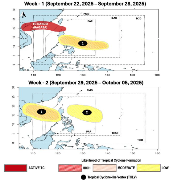
The incoming tropical cyclone-like system is expected to continue toward the West Philippine Sea before exiting PAR next week, or from September 29 to October 5, based on PAGASA's bulletin.
The state weather bureau said the likelihood of the tropical cyclone-like system developing into a tropical cyclone is expected to remain "moderate" all throughout.
Second system being tracked
Meanwhile, a second tropical cyclone-like vortex could form east of Luzon and the Visayas during the second week of the forecast period (September 29 to October 5), though PAGASA said it has a "low chance" of becoming a tropical cyclone.
PAGASA said the tropical cyclone threat potential remains elevated throughout the forecast period due to these developments.
The entire Babuyan Islands remains under Signal No. 5, while Signal No. 4 has been hoisted over southern Batanes and northern sections of mainland Cagayan and Ilocos Norte.


- Latest
- Trending