Twin cyclones 'Dante', 'Emong' drawn in a Fujiwhara effect
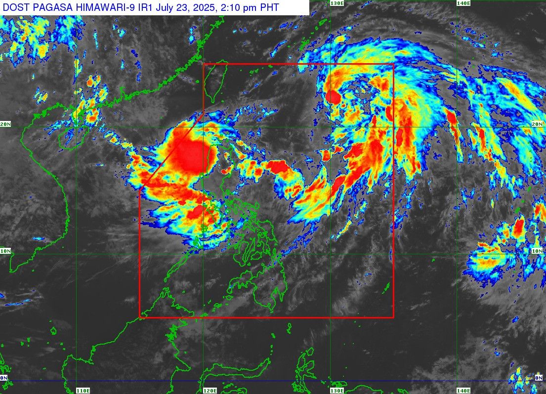
MANILA, Philippines — Tropical Storm Dante’s influence is steering Tropical Depression “Emong” southward in what meteorologists call the Fujiwhara effect.
PAGASA weather specialist Benison Estareja said on Wednesday, July 23, that Dante is keeping Emong over Ilocos Region temporarily before it exits the Philippine area of responsibility (PAR).
He explained that the interaction comes from the cyclones' proximity to each other. PAGASA Administrator Nathaniel Servando added that when two cyclones are positioned less than 1,500 kilometers apart, they form a “binary interaction.”
In the case of Dante and Emong, the two cyclones are only 1,100 kilometers apart. According to PAGASA’s 11 a.m. bulletin, Dante was located 900 kilometers east of extreme Northern Luzon, while Emong was 115 kilometers west-northwest of Laoag City, Ilocos Norte.
“Maaaring habang kumikilos pa-hilaga itong si Storm Dante na siyang dominante na relatively mas malakas siya kumpara dito kay Bagyong Emong, so magdidikta po doon sa kilos nitong si Bagyong Emong ‘yung pagkilos nitong si Bagyong Dante,” Estareja said at a press briefing.
(As Storm Dante moves northward, it may dictate the path of Tropical Depression Emong, given that Dante is relatively stronger and currently the dominant system.)
Emong is speeding west southwestward at 35 kilometers per hour, while Dante takes a slower north northwestward track at 15 kilometers per hour.
How the Fujiwhara effect works
A Fujiwhara effect happens when two cyclones get close enough to spin around each other. This can shift their paths or cause them to combine into one stronger system.
Estareja said that Dante's stronger circulation is forcing Emong to loop over the Ilocos Region, preventing the weaker system from moving forward and exiting PAR. In Servando’s words, Dante is “pulling” the weaker weather system.
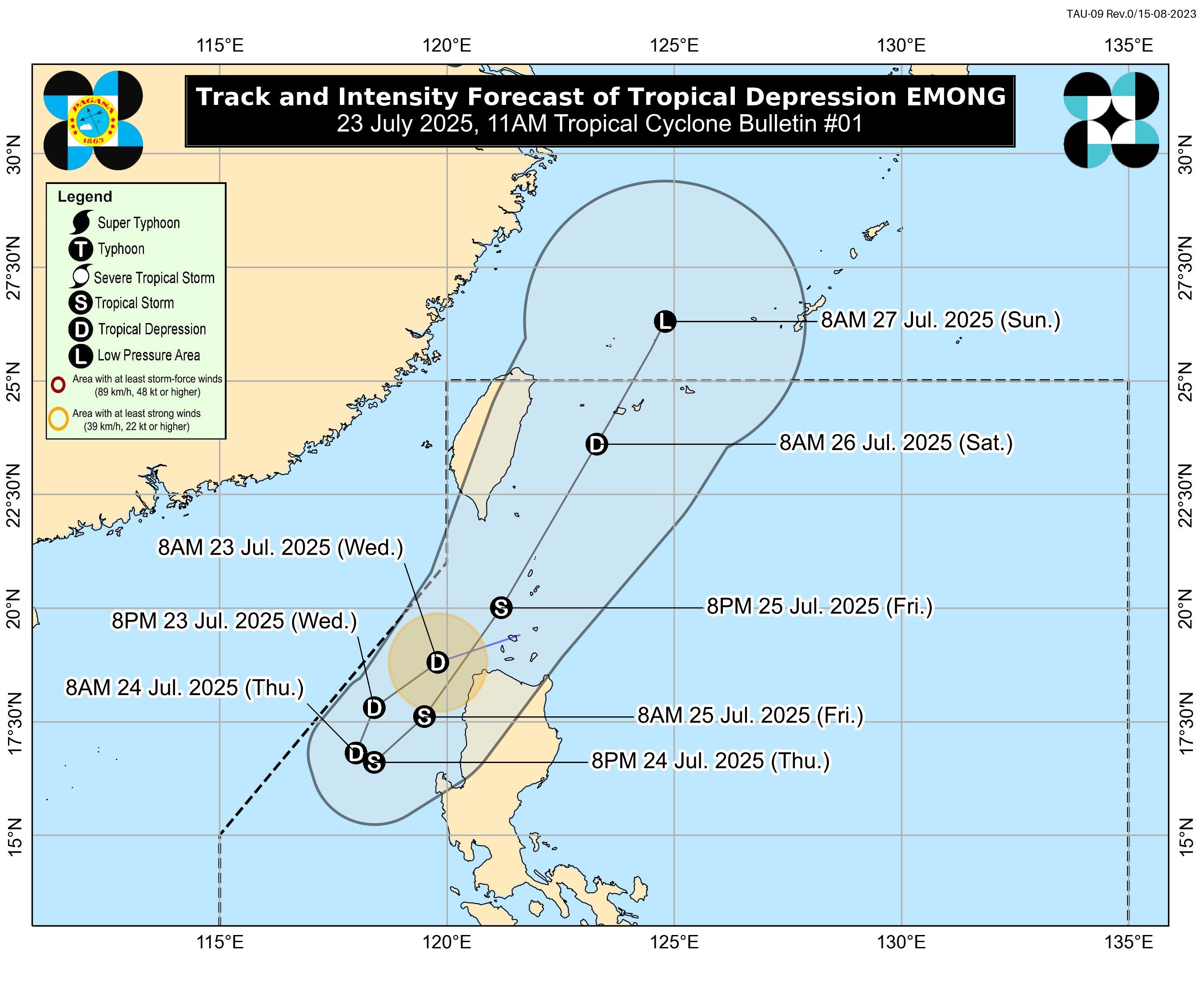

Once Dante leaves PAR and moves toward Eastern China, Emong will follow suit and leave the area, Estareja added. There is, however, a possibility the two cyclones could merge if they draw nearer to each other while moving out of PAR, Servando said.
For now, PAGASA forecasts Emong to bring rains over the Ilocos provinces and other parts of Northern Luzon until Friday, given its sluggish movement.
“Mula ngayon hanggang friday mapapansin natin na halos dito lang sa vicinity ng Ilocos Norte, o Ilocos provinces (ang Bagyong Emong). So expect na po natin dahil mabagal siya at magbababad diyan ‘yung concentration po ng paulan, asahan na po diyan sa part ng Ilocos Region at ilang part ng Northern Luzon,” PAGASA weather services chief Juanito Galang said.
(From now until Friday, Emong is expected to hover near Ilocos Norte and the rest of the Ilocos provinces. So we can expect that with its slow movement, heavy rainfall will likely be concentrated over the Ilocos Region and parts of Northern Luzon.)
Enhanced habagat rains
While both tropical cyclones remain within Philippine waters with potential for further intensification, PAGASA meteorologists warn they will strengthen the southwest monsoon (habagat) that has already brought a week of heavy rains to the country.
“Of course… ‘yung tinitignan natin, dahil kapag andyan ang dalawang system, we expect ma-enhance ang pag-ulan tulad ng habagat,” Servando said.
(Of course… what we’re watching out for, because when two systems are present, we expect enhanced rainfall like the habagat.)
Meanwhile, Estareja said monsoon rains are still expected to prevail over the coming week, especially while there is still one more low-pressure area being monitored outside PAR.
PAGASA has hoisted Wind Signal No. 1 over parts of Luzon as Emong, which could make landfall over Ilocos, the Babuyan Islands, or Batanes.
Dante is forecast to leave PAR by Friday morning, July 25, with Emong likely to exit by Sunday, July 27.
RELATED: Why Metro Manila roads turn into rivers when it pours




- Latest
- Trending