


More Visayas, Mindanao areas under Signal No. 1 due to ‘Kabayan’
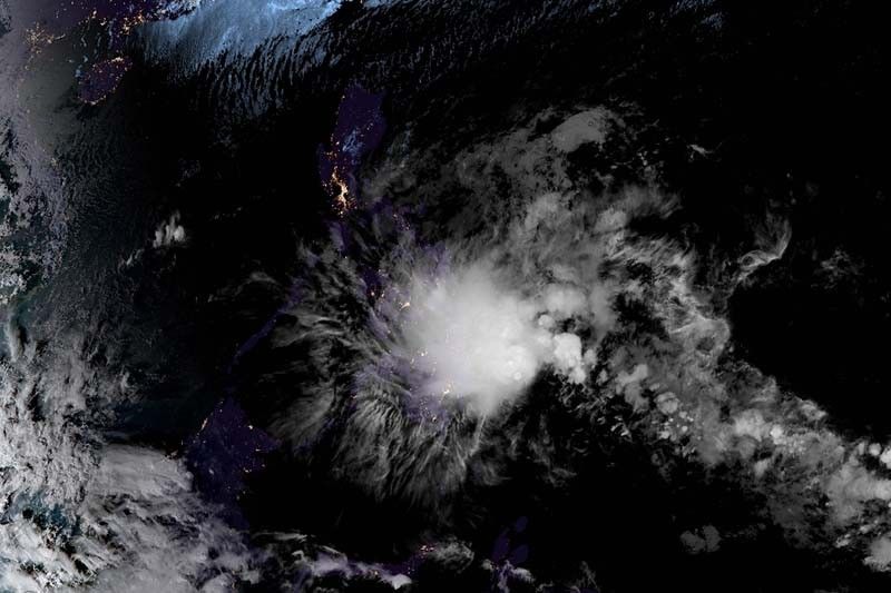
MANILA, Philippines — More areas in Visayas and Mindanao were placed under Wind Signal Number 1 as Tropical Depression Kabayan moved closer to the Philippine landmass, the country’s weather agency said Sunday afternoon.
Kabayan, the country’s 11th cyclone this year, was last spotted 385 kilometers east of Davao City in Davao del Sur or 315 km east southeast of Hinatuan in Surigao del Sur.
The tropical depression maintained its peak winds of 55 km per hour and gusts of up to 70 kph.
Moving west slowly, Kabayan may make landfall along the coast of Surigao del Sur or Davao Oriental Sunday evening or early Monday.
PAGASA placed the following areas under Wind Signal Number 1:
- Southern Leyte
- Leyte
- Samar (Basey, Santa Rita, Marabut, Talalora, Villareal, Pinabacdao)
- Eastern Samar (Maydolong, City of Borongan, Quinapondan, Guiuan, Lawaan, Balangiga, Llorente, Giporlos, Salcedo, Balangkayan, General Macarthur, Hernani, Mercedes)
- Cebu including Camotes Islands, Bantayan Islands
- Bohol
- Siquijor
- Dinagat Islands
- Surigao del Norte including Siargao - Bucas Grande Group
- Surigao del Sur
- Davao Oriental (Cateel, Boston, Baganga, Manay, Caraga)
- Agusan del Norte
- Misamis Oriental
- Camiguin
- Bukidnon
- Agusan del Sur
- Davao de Oro
- Misamis Occidental
- Lanao del Norte
- Lanao del Sur
- Davao del Norte (Santo Tomas, New Corella, Braulio E. Dujali, City of Panabo, Asuncion, City of Tagum, Talaingod, Carmen, Kapalong, San Isidro)
- Davao del Sur (Davao City)
- Cotabato (Arakan, Carmen, Banisilan, Alamada, President Roxas, Kabacan, Matalam, Antipas, Magpet)
- Maguindanao del Norte (Buldon, Barira, Matanog)
The weather agency warned that “minimal to minor impacts from strong winds” are possible in any of the areas under Wind Signal Number 1.
Heavy rain
According to PAGASA, Kabayan will dump heavy rain to parts of Visayas and Mindanao.
Surigao del Sur, Surigao del Norte, Dinagat Islands and Southern Leyte are expected to receive an accumulated rainfall of 100 to 200 millimeters until Monday afternoon.
Meanwhile, Eastern Visayas, Davao region, Northern Mindanao, and the rest of Caraga will have an accumulated rainfall ranging between 50 and 100 mm.
Rainfall is expected to be higher in mountainous areas. This may result in flooding and landslides, particularly in areas highly susceptible to these hazards and those that have experienced significant rainfall in recent days.
The shear line, a weather system formed when cold and warm winds converge, may also bring heavy rainfall to the eastern portion of southern Luzon Sunday and the eastern portion of Luzon Monday.
PAGASA added the surge of northeast monsoon or amihan will also bring gusty conditions for the next two days to the following areas not under any wind signal, especially in coastal and upland areas:
- Batanes
- Babuyan Islands
- Ilocos Norte
- Ilocos Sur
- Aurora
- Bataan
- Bulacan
- Rizal
- Quezon province
- Lubang Island
- Marinduque
- Cuyo Islands
- Bicol region
- Visayas
- Northern and eastern portion of mainland Cagayan
- Eastern portions of Isabela and Nueva Ecija
- Portions of Cordillera Administrative Region, Zambales, Pampanga, Cavite, Mindoro provinces
Once it makes landfall in Mindanao, Kabayan is forecast to cross the area’s rugged terrain and emerge over Bohol Sea or Sulu Sea Monday morning or afternoon.
PAGASA said that Kabayan is forecast to weaken over land after landfall and the possibility of being downgraded into a low pressure area is not ruled out. In such a case, however, redevelopment into a cyclone may still occur over the Sulu Sea.
Kabayan will move across the Sulu Sea south of Cuyo Islands for the remainder of Monday and into early Tuesday.
The cyclone is forecast to make another landfall over central or southern Palawan as a tropical depression by Tuesday morning. It may pass near or over the Kalayaan Islands in the West Philippine Sea.
“It is imperative to stress that the projected track and intensity of the tropical depression remain subject to change, given its nature and strength,” PAGASA said.
The Philippines has so far experienced fewer storms in 2023 than in any of the past 25 years. Only 11 have made landfall or come close so far this year. The archipelago is usually affected by around 20 cyclones a year.
Forecast position
- Dec. 18, 2023 02:00 AM - 130 km east southeast of Hinatuan, Surigao del Sur
- Dec. 18, 2023 02:00 PM - Over coastal waters of Laguindingan, Misamis Oriental
- Dec. 19, 2023 02:00 AM - 295 km west of Dumaguete City, Negros Oriental
- Dec. 19, 2023 02:00 PM - 115 km west of Puerto Princesa City, Palawan
- Dec. 20, 2023 02:00 AM - 150 km southeast of Pag-asa Island, Kalayaan, Palawan
- Dec. 20, 2023 02:00 PM - 80 km west southwest of Pag-asa Island, Kalayaan, Palawan (outside PAR)
- Dec. 21, 2023 02:00 PM - 370 km west southwest of Pag-asa Island, Kalayaan, Palawan (outside PAR)
- Dec. 22, 2023 02:00 PM - 680 km west southwest of Pag-asa Island, Kalayaan, Palawan (outside PAR)


- Latest
- Trending


