


'Ineng' maintains strength over northern Luzon
MANILA, Philippines — Typhoon "Ineng" (international name Goni) maintained its strength early Friday as it changes direction over northern Luzon.
In a 6:42 a.m. advisory, state weather bureau PAGASA said the typhoon was located 170 kilometers east of Calayan, Cagayan province at 4 a.m.
PAGASA weather forecaster Jori Loiz said the eye wall of Typhoon Ineng will be in the vicinity in Batanes by Friday evening.
The weather system sustains maximum winds of 170 kilometers per hour (kph) near the center and gustiness of up to 205 kph. It is moving west northwest and the speed decelerated from 11 kph to 7 kph.
In a state news report, Loiz explained that a typhoon usually moves slow when it changes direction, as a car does when it moves toward a curb and slows down.
The estimated rainfall amount is from moderate to heavy within the 600-kilometer diameter of the typhoon. Several areas in northern Luzon were placed under storm warning signals.
Signal No. 3 (121 - 170 kph winds in 18 hours)
- Batanes Group of Islands
- Northern Cagayan
- Babuyan
- Calayan Group of Islands
Signal No. 2 (61 -121 kph winds in 24 hours)
- Rest of Cagayan
- Northern Isabela
- Kalinga
- Apayao
- Abra
- Ilocos Norte
Signal No. 1 (30 - 60 kph winds in 26 hours)
- Rest of Isabela
- Ifugao
- Mt. Province
- Benguet
- La Union
- Ilocos Sur
If it maintains its speed and movement, Ineng is expected to exit the Philippine area of responsibility by Sunday evening or early Monday morning toward the southern island of Japan, Loiz said.
Fisherfolk are advised not to venture out over the eastern seaboards of central Luzon, the seaboards of southern Luzon and the eastern seaboard of Visayas.
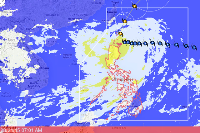
PAGASA's forecast track of Typhoon "Ineng" as of Friday morning, Aug. 21, 2015. Project NOAH
Loiz said the typhoon-enhanced southwest monsoon or "habagat" will bring occasional rains over central Luzon, Metro Manila, Cavite, Laguna, Batangas, Rizal and Quezon, Mindoro, Marinduque, Romblon and Palawan, Bicol Region and Western Visayas.
Cloudy skies with light to moderate rains and isolated thunderstorms are expected over the rest of Visayas and partly cloudy to cloudy skies with isolated thunderstorms will prevail over Mindanao.
PAGASA also expects stormy weather with rough to very rough seas on Friday will prevail over Batanes, Ilocos Norte, Isabela, Kalinga, Apayao, Abra, and Cagayan including Calayan and Babuyan Group of Islands while rains with gusty winds over the rest of Cordillera and the provinces of La Union and Ilocos Sur.


- Latest
- Trending


