Storm may hit Eastern Visayas
MANILA, Philippines — The approaching tropical storm with the international name 'Hagupit' may intensify into a typhoon before entering the Philippine Area of Responsibility this week, the state weather bureau said Tuesday.
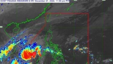
In a televised press briefing past 3 p.m., the Philippine Atmospheric, Geophysical and Astronomical Services Administration (PAGASA) said Hagupit was last located at 2,325 kilometers east of Mindanao.
The storm was packing with maximum winds of 75 kilometers per hour near the center and gusts of 90 kph. It was forecast to move west northwest at 35 kph.
PAGASA senior weather forecaster Rene Paciente said Hagupit may enter the PAR before Thursday noon. It will be named 'Ruby.'
Paciente said the storm may make landfall in Eastern Visayas and barrel through the country but it may also recurve toward the southern islands of Japan.
Before it makes a possible landfall, Hagupit will have maximum sustained winds of 150 kph to 175 kph. It will dump moderate to intense rains to the areas along its track and may generate storm surges of up to four meters.
Coastal waters along the eastern seaboard of Southern Luzon, Visayas and Northern Mindanao will be rough to very rough which will be dangerous to all sea vessels.
If it recurves toward Southern Japan, Hagupit may bring moderate to occasionally heavy rains over the eastern sections of Southern Luzon and Visayas.
Landrico Dalida Jr., PAGASA's officer-in-charge for operations and services, said Hagupit may not intensify into a super typhoon based on their data so far.
Preparation
The Cebu City Disaster Risk Reduction and Management Council advised Cebuanos to be prepared. Councilor Dave Tumulak, chairman of the local disaster council, told the public to be extra vigilant and offer prayers as Ruby is expected to bring heavy rains and strong winds like super typhoon Yolanda did last year.
He also warned cellular phone users not to create chaos and panic by spreading fraud typhoon messages.
In a disaster conference yesterday, he said Ruby has been gaining strength due to warm seas.
"Magkakusog tungod sa kainit. Mo-accelerate man ang iyang kakusog basta init ang dagat. We are expecting nga same with Yolanda ang kakusog as of today (yesterday) but we are hopeful nga ma-change ang path the next few days. Expect heavy downpour," he said.
He said Ruby is expected to enter the PAR by Thursday or Friday with a speed of 85 kilometers per hour and make landfall probably Sunday night, affecting parts of the Eastern Visayas and Mindanao.
Tumulak said he has already convened and informed different government agencies, disaster brigades and emergency response volunteers calling for collaborated contingency plans. As part of the contingency plan, the disaster office has set synchronized communication connectivity with BFP, PNP, BJMP and DILG.
Tumulak asked policemen not to take vacation leaves as police visibility is needed during disasters and response operations. However, this order should still come from the regional headquarters.
"Kinahanglan g'yud ta og sufficient manpower. We need PNP and other volunteers from government agencies to help in the undertaking," he said.
The barangay disaster brigades were tasked to submit a list of numbers of every barangay worker, sitio leader, principal and chapter leaders for easy and convenient dissemination of weather advisories.
The price monitoring body of the city has already started checking the prices of commodities to prevent possible hoarding.
For the disaster and medical supplies, Tumulak said there is an ongoing inventory of rescue equipment, goods and communication equipment, among others.
Tumulak said bankers have assured that automated teller machines will have sufficient money.
Evacuation
The city is expected to carry out preemptive evacuation if the weather will worsen and if the situation permits. However, evacuation sites near coastal barangays like Pasil, Duljo-Fatima and Ermita are not allowed.
"Gidili gyod nato ang evacuation sites sa mga coastal barangays labi na kay expected taas ang taob gikan Friday ngadto Sunday," he said.
He said the evacuation sites must be on high ground and equipped with electricity, water and proper accessibility.
Vernel Balaba, Regional Operations Officer of the Office of the Civil Defense 7, said those who are living in disaster risk areas will be prioritized for evacuation.
He said that to prevent loss of lives the public should evacuate themselves as early as possible in the pre-emptive evacuation rather than be forced to evacuate.
"When you say forced naa na ang hangin; pre-emptive, wala pa ang kusog nga hangin, wala pa ang taas nga tubig," he said.
Balaba said that they still have not lifted the red alert status after tropical depression Queenie hit Central Visayas region.
Balaba added that the preparations include a pre-disaster meeting with all the major responding national agencies and four Provincial Disaster Risk Reduction Management officers or their representatives today.
He said that OCD relies on the media to disseminate information relevant to the safety of the public. He also advised the public to be security conscious all the times.
"Pahimangno lang nga dili na unta ug wala na unta na nato'ng huna-huna nga kompiyansa ug makat-on na ta sa atong silingan nga rehiyon," Balaba said.
He emphasized that need for cooperation and said that the public should follow the authorities.
"Ang nahitabo sa Yolanda even though na-disseminate ang information naa lang gihapo'y gahi'g ulo. We must strictly adhere to what the authority nga naghatag og pahimangno," he added. — (FREEMAN)
- Latest
- Trending


