Mawar slightly weakens, but may reintensify
MANILA, Philippines - Tropical cyclone Mawar has slightly weakened into a typhoon, but is forecast to reintensify into a super typhoon before it enters the Philippine area of responsibility (PAR) this weekend.
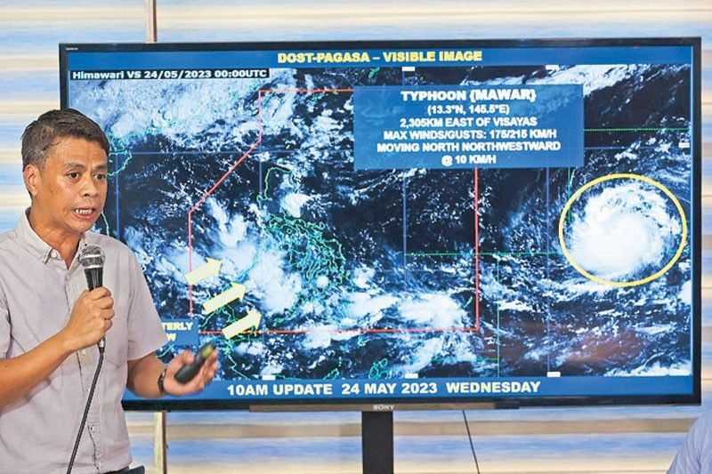
Mawar had been monitored 2,135 kilometers east of the Visayas as of 3 p.m. yesterday, according to the Philippine Atmospheric, Geophysical and Astronomical Services Administration (PAGASA).
It was carrying maximum sustained winds of 175 kilometers per hour and gustiness of up to 215 kph.
Mawar may enter the eastern boundaries of the PAR by Friday evening or Saturday morning, after which it will be given the local name Betty, according to weather forecasters.
Mawar weakened to typhoon category yesterday, but PAGASA said that it may re-intensify due to warm atmospheric conditions as it traverses the Philippine Sea.
PAGASA noted that Mawar has around 300 km radius and rainbands that could directly affect Northern Luzon by Sunday or Monday.
Rainbands could affect Cagayan Valley between Sunday and Tuesday, with a possibility of the hoisting of the tropical cyclone wind signal over areas in the province.
Mawar could also enhance the monsoon rains over the western portions of Mimaropa (Mindoro provinces, Marinduque, Romblon, Palawan), the Visayas and Mindanao from Friday to Saturday.
The monsoon could also affect parts of Southern Luzon and the Visayas starting Sunday.
Still, PAGASA said there could be changes in the impact of the southwest monsoon as this depends on Mawar’s track and intensity.
PAGASA added that almost similar cyclones were seen in the past years, most notably Typhoon Paeng last year and Typhoon Urduja in 2017, that originated from the same area as that of Mawar.
Today, the southwesterly windflow will bring scattered rainshowers over several parts of the country.
Cloudy skies are forecast over Occidental Mindoro, Palawan, Western Visayas, Northern Mindanao, Soccsksargen (South Cotabato, Cotabato, Sultan Kudarat, Sarangani, General Santos), Zamboanga peninsula and the Bangsamoro Autonomous Region in Muslim Mindanao.
Metro Manila and the rest of the country may experience isolated rainshowers due to the southwesterly windflow and localized thunderstorms.
Alerted
As Mawar approaches the country, the National Disaster Risk Reduction and Management Council (NDRRMC) yesterday alerted coastal towns to brace themselves for the impact of the typhoon.
In a disaster media bulletin, NDRRMC and Office of Civil Defense (OCD) spokesman Assistant Secretary Raffy Alejandro IV said that in view of Mawar, the OCD and its regional offices will continuously monitor the situation and coordinate with concerned member agencies.
“We are alerting coastal communities as far as Bicol because this is a super typhoon. This will create large waves. Our fisherfolk will be affected. We will need to temporarily ban fishing trips,” Alejandro said.
“(We) initially alerted LGUs (local government units) located in the eastern seaboard of the country as Mawar will be coming from the eastern side of the country. However, we are now also alerting LGUs on the western seaboard as the tropical cyclone will also intensify and pull the southwest monsoon that will cause strong winds and rains,” he added.
Alejandro disclosed that the NDRRMC/OCD would conduct pre-disaster risk assessment with science agencies to determine LGUs that are susceptible to the effects of the tropical cyclone and subsequently their prescribed alert levels and corresponding response protocols.
The OCD has also placed its rescue and response teams on alert and on standby as Mawar approaches the country.
Stockpiling and prepositioning of relief goods and other items are also being carried out with possible pre-emptive evacuation efforts in some towns in Cagayan and in coastal towns in Batanes.
Alejandro said LGUs in Northern Luzon are expected to conduct pre-emptive evacuation, especially for those in coastal towns and areas prone to floods and landslides.
Mawar is fast approaching Batanes and parts of Cagayan and the pre-emptive evacuation may likely be implemented over the weekend, according to the NDRRMC/OCD.
Farmers, fisherfolk
Meanwhile, an official of the Department of Agriculture (DA) yesterday urged farmers and fisherfolk to prepare ahead of the expected entry of Mawar into the PAR.
DA deputy spokesman Assistant Secretary Rex Estoperez said the agency is closely coordinating with PAGASA on latest developments.
Estoperez appealed to farmers and fisherfolk to always tune in “to save us from the effects of the calamities.”
The DA also encouraged farmers to implement early harvest to spare their crops from the devastation of the typhoon.
Airports prepare
In a related development, airports under the management of the Civil Aviation Authority of the Philippines (CAAP) are actively implementing precautionary measures in anticipation of Mawar’s strength.
CAAP spokesman Eric Apolonio yesterday said airports located in areas along the possible path of Mawar, such as Ilocos and Cagayan Valley, have conducted pre-typhoon coordination meetings, assessments and preparations to gear up for possible weather disturbance.
Apolonio added that Malasakit help kits, including food packs, are also in place to be distributed to affected travelers if the typhoon lands in those regions.
In anticipating Mawar’s onslaught, the Media Affairs Division of the Manila International Airport Authority said that as of 2 p.m. yesterday, United Airlines had canceled its Guam-Manila-Guam flights – UA 183/184 – due to unfavorable weather condition caused by Mawar. – Jose Rodel Clapano, Michael Punongbayan, Rudy Santos


- Latest
- Trending